


Coral reefs are in global decline due to unprecedented anthropogenic threats that have escalated and accumulated over decades to centuries. In order to assess the magnitude and drivers of changes on reefs, it is necessary to reconstruct the history of changes of these ecosystems over this longer time scale. We compiled and assessed historical records of naturalists that visited Abrolhos reefs over the last 202 years, and compared a 160-year-old nautical chart with modern charts to quantify losses in the spatial extent of coastal reefs in the Abrolhos Bank, Brazil. We found a 28% loss in the overall spatial extent of inshore reefs, with some areas experiencing declines up to 49% over the past 160 years. Such reefs with more dramatic changes (Guaratibas reefs) are the closest to the coast (∼7 km), where local impacts such as the past extraction of coral for lime since the 19th century, as well as increased coastal sedimentation and siltation due to deforestation are concentrated and that, combined, may have caused the observed decline. Collectively, this set of historical information captures coral reef changes over time, and helps update conservation and restoration goals for the Abrolhos reefs seascape.
Coral reefs are the most productive and biodiverse marine ecosystems, providing critical services and economic benefits such as food provision, coastal protection, and carbon sequestration (Bellwood et al., 2003; Pratchett et al., 2014). The coral fauna plays key functions in reef ecosystems including calcification, photosynthesis, and nutrient cycling (Bellwood et al., 2003). Coral reefs also figure amongst the most impacted marine ecosystems on Earth (Knowlton and Jackson, 2008; Morrison et al., 2019). Among the main causes of reef degradation are global warming, overfishing, pollution, and habitat loss (Morrison et al., 2019). These escalation and accumulation of anthropogenic impacts over the scale of centuries have greatly altered coral reefs, with impacts, such as direct exploitation and increased sedimentation, occurring long before the start of ecological data collection (Knowlton and Jackson, 2008). Therefore, to understand the full magnitude and drivers of changes on these environments over time, it is necessary to use paleo-ecological and historical-ecological research methods (e.g., Knowlton and Jackson, 2008; McClenachan et al., 2017).
Alternative sources of information, including historical maps, photographs, reports by naturalists, and interviews with fishers, are being used to reconstruct change over time in marine ecosystems (Kittinger et al., 2011; McClenachan et al., 2017). Most research in the field of historical marine ecology has focused on changes in the composition, abundance, richness, and body size of fishes and other marine vertebrates. In contrast, less is known about spatial changes in the structural integrity of marine habitats in comparison to their condition prior to the intensification of human activities and derived impacts. One valuable source of information on long-term spatial change in marine ecosystems is historical charts (Collen et al., 2009; Watts et al., 2015; McClenachan et al., 2017). Nautical charts created to assist navigators in the 18th and 19th centuries sometimes contain important ecological information, such as macrohabitat positioning, extension, and gross composition (e.g., sand, coral, shells, and rocks). Using this type of information, previous studies revealed shoreline changes and sediment redistribution at Palmyra Atoll, in the Pacific Ocean (Collen et al., 2009). In addition, historical bathymetric charts were used to estimate changes in seafloor depth over the past 150 years in the Santorini region, Greece (Watts et al., 2015). These works demonstrate the potential of using alternative sources of information to reconstruct the past condition of reefs.
Historical maps and charts are an important source of information to estimate long-term changes in land and seascape, across a range of habitats. For instance, McClure and Griffiths (2002) combined historical maps and aerial photography to assess the historical processes that have shaped the landscape of the Royal Forest of Wychwood, England. In freshwater ecosystems, historical maps were used to investigate changes in water levels and storage capacity of Lake Okeechobee (Rivero et al., 2020). In nearshore coastal ecosystems, maps dating from the early 19th century and historical records were used to recreate the urban landscape and topography of Boston's Inner Harbor (Maio et al., 2013). The growing use of nautical charts in marine habitats includes work in kelp forests and coral reefs; for example, Pfister et al. (2018) compared nautical maps (1911–1912) with aerial censuses (1989–2015) of canopy kelp species to determine the persistence of kelp cover over the past century in Washington State (USA) waters. McClenachan et al. (2017) identified a high percent loss (68.8%) in nearshore reefs comparing three historical charts in Florida Keys. The wide range of habitats covered by these studies suggests that maps are an important source of information on large scale spatial change in marine, freshwater, and terrestrial ecosystems around the world.
Despite the growth of historical marine ecology and the promise of alternative sources of information to assess changes to reefs, the majority of historical ecological research has focused on Northern Hemisphere geographies with English speaking colonial histories, leaving major information gaps in much of the world (Beller et al., 2020). Coral reefs largely fall outside of this geographic scope. Likewise, within the field of coral ecology, there is a recognized global mismatch of research effort and conservation need, with most of the research effort focused on a few locations (Fisher et al., 2011). Also, most coral reefs are located in low and middle-income countries, where data to investigate the past of reef ecosystems are lacking (Kittinger et al., 2011). Beyond being cost-effective, the use of historical information provides a particularly valuable contribution to understanding long-term global changes to coral reef ecosystems in Southern Hemisphere and non-English speaking countries (Fisher et al., 2011; Beller et al., 2020).
In the South Atlantic, Brazilian coral reefs harbor a highly endemic fauna that provides critical benefits to coastal populations, including food provision, livelihood opportunities through tourism, carbon sequestration, and protection from storms (Mies et al., 2020). These reefs harbor a lower diversity of shallow-water zooxanthellate corals and hydrocorals (∼20 species) in comparison to Caribbean and Indo-Pacific reefs, but reveal a remarkably high proportion of endemic reef-building corals (Mies et al., 2020). The Abrolhos Bank is the largest (∼48.899 km²) and most diverse reef complex of the South Atlantic, with unique features as a multitude of habitats (Moura et al., 2013), including mushroom-shaped coralline pinnacles and the largest continuous rhodolith bed of the world (Moura et al., 2013). This region is partially protected by the first National Marine Park in Brazil, established in 1983 (Leão et al., 1996), but still suffers from several threats such as overfishing and oil and gas production (Moura et al., 2013).
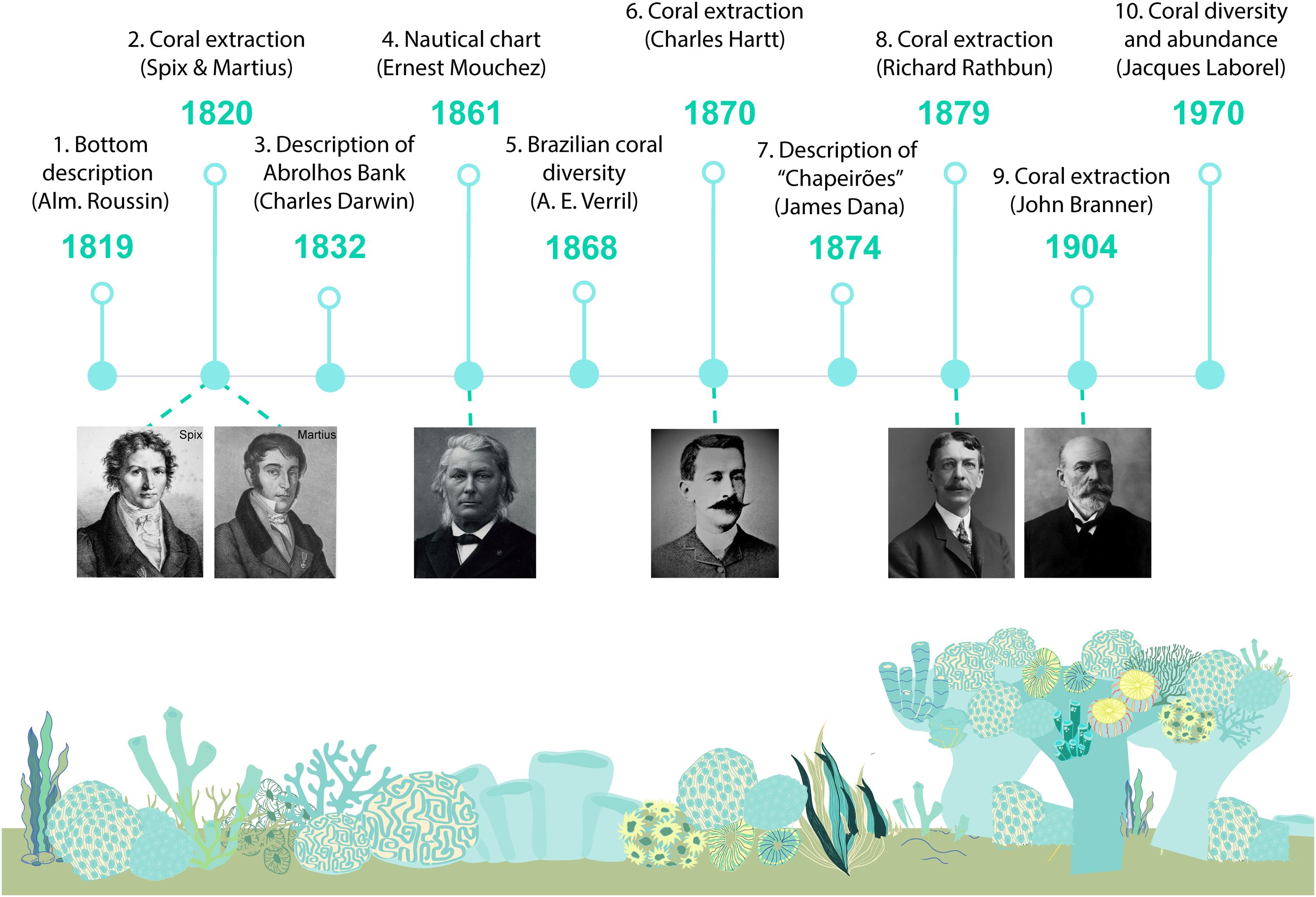
In 1500, an armada set out from Portugal to the Indies, but reached Brazilian shores instead. The Portuguese fleet landed in Porto Seguro, approximately 200 km from the Abrolhos region. Three years later, the expedition led by Italian navigator Américo Vespucci possibly gave rise to the first settlement in Caravelas (17°42′49″ S, 39°14′54″ W), near Abrolhos (Barros, 2016). The first written accounts of the Abrolhos region possibly date from 1560 and refer to the shipwreck of Priest José de Anchieta (Barros, 2016). In those early settlements, colonizers harvested the highly-valued pau-brasil trees (red wood for making dye). By the 17th century, the village of Caravelas covered a broad territory extending further south, to Espírito Santo state. In the mid-1800s, coffee farms and infrastructure as railroads contributed to the economic and urban development of the region (Barros, 2016). During this period, Caravelas’ population was estimated at 2000 people, most of which were whale fishers (Hartt, 1870). For centuries, the Abrolhos Bank has been an ancient and important fishing area, with groupers and whales as major historical fishing targets (Hartt, 1870). The history of Abrolhos is marked by many visits of European naturalists and navigators sponsored by the Portuguese crown to collect information about Brazilian nature, native inhabitants and landscape (Spix and Martius, 1828; Roussin, 1845; Hartt, 1870; Branner, 1904; Laborel, 1970). During scientific expeditions, explorers navigated the Abrolhos Bank with the help of nautical charts. Consequently, historical charts contained details on the location and area of coral reefs, and other habitat types, being a potentially relevant source of information for adjusting references on possible temporal changes in the location and spatial extent of coral habitats (McClenachan et al., 2017).
We investigated the magnitude of historical changes in the reef areas of the Abrolhos Bank, by comparing the spatial extent of reef habitats recorded on a historical nautical chart that contains information from 160 years ago (1861) with modern maps based on remote sensing data for Abrolhos’ reefs. We complemented the construction of this past scenario with reports from naturalists, navigators and researchers who travelled through the region over the course of 202 years, which we used to assess early anthropogenic drivers of change.
Materials and methodsStudy areaThe Abrolhos reefs (16º40ʹ,19º 40ʹ S – 39º10ʹ, 37º20ʹ W) are distributed in two arcs – the Coastal and Outer arcs – lying almost parallel to the mainland shore. The inner shelf, also called the Coastal arc, is located between 10 and 20 km offshore and is formed by shallow bank reefs and isolated coral pinnacles of varying dimensions (Moura et al., 2013). The mid shelf, or Outer arc, is ∼70 km offshore and formed by isolated giant coral pinnacles (popularly called “chapeirões”) and the rocky reefs of the Abrolhos Archipelago. The tops of these giant pinnacles are deeper (>10 m) than the bank reefs of the Coastal arc (Dutra et al., 2006). The term “chapeirões” was introduced by geologist Charles Hartt in 1870, which alludes to wide-brimmed hats, hats being translated to “chapéus”, in Portuguese (“chapeirões” is the augmentative) (Hartt, 1870).
Historical dataThe historical chart of the Abrolhos Bank was developed by the born-Spanish cartographer and astronomer Admiral Ernest Amédée Barthélemy Mouchez during expeditions along the Brazilian coast, in 1861 (Fig. S1). Admiral Ernest carried out numerous expeditions to South America between 1856 and 1861. His surveys included the Paraguay river, from Paraná to Asunción, and numerous regions on the coast of Brazil, from Bahia to Rio de Janeiro (12º58ʹ16ʺ S, 38°30ʹ39ʺ W – 22°54ʹ10ʺ S, 43°12ʹ 27ʺ W) and even reaching the austral Lobos Island (29°20ʹ48.0ʺ S, 49°42ʹ17.4ʺ W) and Tramandaí (29º59ʹ 05ʺ S, 50º08ʹ 01ʺ W).
We obtained this chart digitalized and in high resolution from the digital collection of the Brazilian National Library (Cart525992 (bn.br)) in Rio de Janeiro (Fig. S1). The chart contains notes on the benthic habitat of the region, including sand bottoms, coral, shells, rocks, gravel, mud, clay, and seagrass beds. In addition, this nautical chart contains information such as specific reference points, hazards, and water depths that contextualize data extracted from the charts. The nautical chart of Mouchez (1861) was georeferenced using fixed reference points on the coast such as estuaries and rivers through Quantum Gis software (QGis; version 3.16.2).
Modern dataTo estimate spatial and temporal changes in the extent of coral reef habitats in the Abrolhos Bank, we compared historical reef areas with areas from three modern reef layers : (1) the Millennium Coral Reef Mapping Project (UNEP-WCMC, WorldFish Centre, WRI, TNC, 2021); (2) shapefiles of coral reefs of the Abrolhos Bank from Moura et al. (2013); and (3) shapefiles of emerged and submerged reefs from Magris et al. (2017). These three layers were derived from high-resolution satellite images, multispectral Landsat 7 images, resolution 30 meters (UNEP-WCMC, WorldFish Centre, WRI, TNC, 2021), Landsat TM (spatial resolution 30 meters) combined with side-scan sonar records (Moura et al., 2013), and Landsat 5 ETM (resolution 30 m) supplemented by multispectral IKONOS (high spatial resolution 4 m) (Magris et al., 2017).
These modern layers were obtained in shapefile format online (https://data.unep-wcmc.org/datasets/1) (UNEP-WCMC, WorldFish Centre, WRI, TNC, 2021) and provided by the authors of papers through supplemental material (Moura et al., 2013; Magris et al., 2017). The combination of modern layers allowed us to detect the occurrence of emerged and submerged corals as well as smaller reefs (i.e., isolated submerged mushroom reefs/coral pinnacles up to 50 meters in diameter). In addition, we used these three different modern sources of information to minimize potential differences in reef area estimates, making the analysis and results more robust and conservative. Alignment of the historical and present nautical chart (Moura et al., 2013; Magris et al., 2017, see below) was performed using the Quantum Gis software (QGis; version 3.16.2).
Comparative analysisTo estimate the potential changes in reef extent (area) through time, we analyzed the following reefs of the Coastal arc: Guaratibas, Timbebas, Recifes do canal (which encompasses the Areia, Cabocla, Aranguera, and Lixa reefs), Sebastião Gomes, Coroa Vermelha, and Viçosa (Table S1). These areas were chosen because they are relatively shallow and thus maps (both historical and recent) tend to be more accurate relative to deeper reefs of the Outer arc.
First, we calculated past reef areas by drawing polygons on historical coral reefs indicated in the nautical chart (Fig. 1A, B). The limits of coral reef areas were based on map legends, in which the author described reef contours as follows “The dotted lines indicate the limits in which banks and the chapeirões [mushroom-shaped growth] are enclosed” (in French: Les lignes ponctuées indiquent les limites dans lesquelles sont reenfermés les bancs et les chaperons). We therefore considered these dotted lines as the limits to past coral reef areas. In addition, we created polygons on emerged coral reefs drawn on the nautical chart. Then, these polygons were used as the basis for creating 220 m² grids both in the historical corals (Fig. 1B) and in the modern layers (Fig. 1C, D). Differences between historical and modern reef area were calculated through the number of grids covering the past and modern reef areas.
 Reefs represented in the historical nautical chart; (b) Grids (220 m²) created from the polygons limiting historical reef areas; (c) Modern reef layer of the Millennium Coral Reef Mapping Project (superimposed colors); and (d) Grids (220 m²) created from the polygons of the modern layer of the Millennium Coral Reef Mapping Project. Viçosa reefs (orange), Coroa Vermelha reefs (light blue) and Sebastião Gomes reefs (pink).")
Method used to estimate temporal changes in reef area for the Abrolhos Bank. (a) Reefs represented in the historical nautical chart; (b) Grids (220 m²) created from the polygons limiting historical reef areas; (c) Modern reef layer of the Millennium Coral Reef Mapping Project (superimposed colors); and (d) Grids (220 m²) created from the polygons of the modern layer of the Millennium Coral Reef Mapping Project. Viçosa reefs (orange), Coroa Vermelha reefs (light blue) and Sebastião Gomes reefs (pink).
Percent loss (PL) in reef areas were calculated according to the following formula:
Where H is the historical area (H) of reef r and M is the modern area of reef r calculated for each modern layer l mentioned above. Pairwise comparisons were made between the historical area and modern area of each reef, and from these values we obtained mean differences and standard deviation. Differences between reefs’ percent loss were tested using a Kruskal-Wallis test. We also used Spearman’s correlation to test the relationship between reef’s percent loss and its distance from the coast. All analyzes were performed on R software version 3.6.1 (R Development Core Team, 2019).Assessing early anthropogenic drivers of change to coastal coral reefs
To increase understanding of historical changes and the potential drivers of change in Abrolhos reefs, we searched archival and published historical literature including naturalist reports, documents, and books, primarily from the 19th century. Most of the naturalists’ reports and books were written in English or translated to Portuguese. The compilation of historical information was made in museums, libraries, and research institutions of two cities—Rio de Janeiro (Rio Janeiro state, southeast Brazil) and Recife (Pernambuco state, northeast Brazil) —, considering the number of historical collections they host (Table S2). We also searched 14 libraries and archives in digital collections (see Table S2 for a complete list of collections). For online searches, we used the following keywords in English and Portuguese: ‘Brazilian reefs’, ‘Abrolhos reefs’, ‘scientific expedition’, ‘coral reefs’, and ‘Southern Bahia’, ‘recifes brasileiros’, ‘recifes de Abrolhos’, ‘expedição científica’, ‘recifes de corais’ e ‘sul da Bahia’. We used information from these sources to build a timeline of observations, and to assess the timing of early anthropogenic drivers of change to nearshore coral reef habitat.
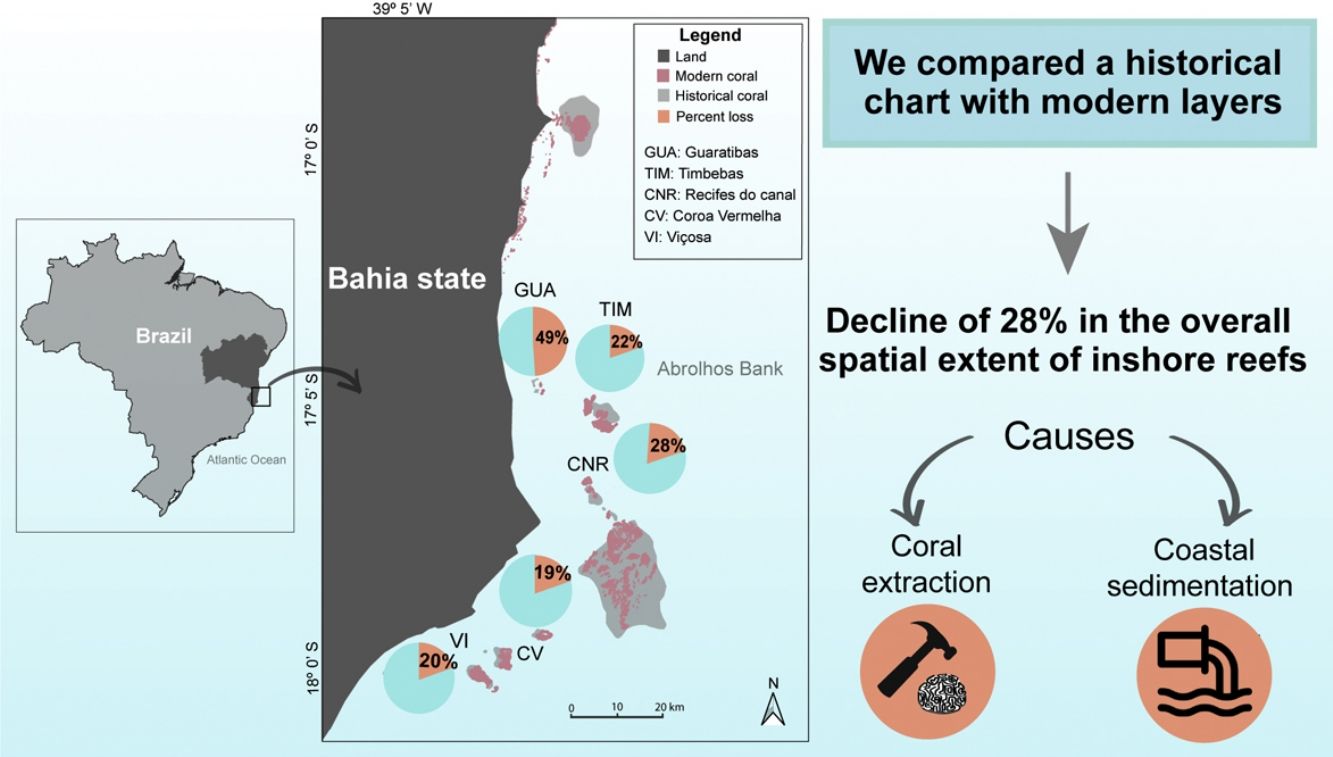
ResultsChanges in reef extentOverall, the assessed reef sites in the Abrolhos Bank lost 28 ± 13% (mean ± standard deviation) of their area (km²). Reef sites with the greatest declines in area were close to the coast (Fig. 2), such as Guaratibas (49% loss, 6.65 km offshore) and Recifes do Canal (28%, 13.9 km), followed by Timbebas (22%, 15.1 km), Viçosa (20%, 11 km) and Coroa Vermelha (19%, 10.5 km) (Fig. 2). Differences in reef percent loss between sites were not significant (Kruskal-Wallis’s test, P-value = 0.406). In addition, there was no significant correlation between percent loss and distance from the coast (Spearman’s test, P-value = 0.95).
, pie charts represent the percent loss (orange) in coral area across different reef locations of the coastal arc. (b) Percent loss by coral reef area. Orange bars represent the mean loss and error bars represent the standard deviation. Coral reefs: Guaratibas (GUA); Coroa Vermelha (CV); Viçosa (VI); Recifes do Canal (CNR) and Timbebas (TIM).")
The loss of coral area in the Abrolhos Bank. In (a), pie charts represent the percent loss (orange) in coral area across different reef locations of the coastal arc. (b) Percent loss by coral reef area. Orange bars represent the mean loss and error bars represent the standard deviation. Coral reefs: Guaratibas (GUA); Coroa Vermelha (CV); Viçosa (VI); Recifes do Canal (CNR) and Timbebas (TIM).
We compiled accounts from navigators and naturalists, which we categorized as observations related to either navigation or ecological attributes. Collectively, these observations show that the Abrolhos Bank has long been a region of interest for travelers and naturalists exploring the Southwestern Atlantic and the Brazilian coast (Fig. S2). In terms of navigation, this region is known for its risks due to the coral formations that caused several shipwrecks. The hazard warnings regarding the Abrolhos reefs were recorded on maps and originated the name of the region, "Abra os olhos" in Portuguese, which can be translated to “Open your eyes”, in English. One of the first shipwrecks recorded in Abrolhos happened to the Priest José de Anchieta, in 1560 (Barros, 2016). Years later, other shipwrecks were recorded, in which the best known were Saint John the Baptist and Prinz Willem, both in 1631, and Guadiana and Rosalinda vessels in 1955 and 1985, respectively (Barros, 2016).
Descriptions of the ecological attributes of Abrolhos reefs occurred more than 200 years ago, when Europeans arrived on expeditions to the coast of Bahia state. European naturalists visited the Abrolhos Bank with an interest in describing its geomorphology, mapping potential navigational hazards as well as documenting the diversity and occurrence of coral reefs in the region (Fig. S2, Table 1). In 1819, the French Admiral Albin Reine Roussin recorded in his work "Pilote du Brésil", instructions for navigation on the Brazilian coast. The work highlights a description of the Abrolhos seabed and the risks to navigation associated to coral habitats (Roussin, 1845). Between 1817 and 1820, the German naturalists Johann Baptist von Spix and Carl Friedrich Philipp von Martius traveled across Brazil to describe the local fauna and flora, including that of the Abrolhos Bank. Some years later, Charles Darwin visited this region and reported in a passage of the book “Geological Observations on the Volcanic Islands” the high abundance of corals in the seabed “the bottom of the sea is entirely coated by irregular masses of coral, which although often of large size, do not reach the surface and form proper reefs” (Darwin, 1851).
Historical observations about coral extraction, ecological description, and navigational hazards of the Abrolhos Bank.
| Report number | Year | Author | Information type | Historical observation |
|---|---|---|---|---|
| 1 | 1819 | Alm. Roussin | Navigational hazards | “The most common ground quality around Abrolhos is a whitish tuff, composed or abundantly mixed with debris of madrepores reduced to powder, and which offers no other variety than its greater or lesser consistency.” |
| 2 | 1817- 1820 | Spix & Martius | Coral extraction | “On the southernmost coasts, especially those of Pôrto-Seguro and Abrolhos, it seems, the fishermen who are engaged in fishing and preparing the grouper…often and also capture very large and precious corals.” |
| 3 | 1832 | Charles Darwin | Ecological description | “Round many intertropical islands, for instance the Abrolhos on the coast of … the bottom of the sea is entirely coated by irregular masses of coral, which although often of large size, do not reach the surface and form proper reefs. This must be owing either to insufficient growth, or to the absence of those kinds of corals which can withstand the breaking of the waves.” |
| 4 | 1861 | Ernest Mouchez | Navigational hazards | Nautical chart of Abrolhos Bank |
| 5 | 1868 | A. E. Verril | Ecological description | “Mussa harttii corallum forming circular clumps, often a foot in diameter and half as high, consisting of numerous short, rapitly forking…” |
| 6 | 1870 | Charles Hartt | Coral extraction | “My boatman said that on the outer edge of the reef large coral heads grew and that these were collected and brought onshore for burning into the lime.” |
| 7 | 1874 | James Dana | Navigational hazards | “Sometimes vessels striking heavily on small chapeirões, break them off and escape without injury, as has been remarked by Mouchez. At other times a vessel may run upon one and stick fast by the middle of the keel, to the amazement of the captain, who finds deep water all around, the vessel being perched on the chapeirões like a weather-cock on the top of a tower.” |
| 8 | 1879 | Richard Rathbun | Coral extraction | “Here and there, the slaves in procuring limestone, have quarried into the low inner part of the reef, and even into the high wall-like portion.” |
| 9 | 1904 | John Branner | Coral extraction | “Some five or six years ago a Rio company shipped the reef rock from Coroa Vermelha to Rio de Janeiro, where it was burned for lime.” |
| 10 | 1970 | Jacques Laborel | Ecological description | “Our documents are reduced for this region to the dredging of the Calypso of which a dozen provided Madréporaires: again, we find the same type of bottoms: soft bottoms to Meandrina braziliensis, hard bottoms to Mélobésiées and Agaricia fragilis, Madracis, etc …” |
In the second half of the 19th century, Canadian-American geologist Charles Frederick Hartt made several notes on Brazilian coral species, with a special passage for corals from southern Bahia. Charles Hartt was a travelling companion of Professor Louis Agassiz during the Thayer Expedition, which produced the first description of coral zonation for the Abrolhos reefs (Hartt, 1870). Between 1874–1879, two other naturalists, James Dana and Richard Rathbun published works on Brazilian coral reefs, focused on Abrolhos. Richard Rathbun described the characteristics and extent of the Brazilian coral reefs. In 1904, the American geologist John Casper Branner published the book “The Stone Reefs of Brazil, their Geological and Geographical Relations”, describing the geology and geography of Brazilian reefs. Along with Hartt and Rathbun, Branner was part of the Imperial Geological Commission, which was created in 1875 and visited the continental reefs in the states of Alagoas, Amazonas, Bahia, Paraná, Pernambuco, Rio Grande do Norte, São Paulo, Santa Catarina, and Sergipe, as well as Fernando de Noronha archipelago. This expedition resulted in the colleciton of approximately 500,000 specimens and important zoological, geological and ethnographic information.
More than a century later, in 1960, another work was fundamental for the understanding of the biological and ecological aspects of Brazilian reefs (Laborel, 1970). French researcher Jacques Laborel wrote his seminal thesis in 1969 entitled “Les peuplements des madréporaires des côtes tropicales du Brésil” (Madreporia populations of the tropical coasts of Brazil). Laborel traveled along the Brazilian coast studying scleractinian corals, which were called “madreporaires”. He visited the reefs between Ceará (3°42ʹ47.5ʺ S, 38°31ʹ39.1ʺ W) and São Paulo states (23°59ʹ24.0ʺ S, 46°20ʹ48.0ʺ W). In the Abrolhos Bank, Laborel described the species composition and abundance (semi-quantitatively) of the chapeirões (Laborel, 1970).
Anthropogenic drivers of change to coastal coral reefsWe identified 10 major works that contain information on the potential drivers of changes in reefs from museums, libraries, and digital collections (Table 1). The first evidence on the anthropogenic impacts on these reefs was reported between 1817 and 1820 by the naturalists Johann Baptist von Spix and Carl Friedrich Philipp von Martius, which mentioned coral extraction as an economic activity in the region (Fig. 3, Table 1). This activity, where corals were burned to make lime that was used in construction, was common along the Brazilian coast and in Abrolhos. For example, the authors write: “These banks can be seen in various parts of the lagoon at a depth of six to twelve feet, and are used in the construction of houses, when there is no lime” (Table 1, Spix and Martius, 1828). Spix and Martius further describe coral collection: “On the southernmost coasts, especially those of Pôrto-Seguro and Abrolhos, it seems, the fishermen…often and also capture very large and precious corals” (Spix and Martius, 1828). Abrolhos Bank was known as an important area of fishing and coral removal, and this practice can be tracked to different periods of time over the history of coral reefs in Abrolhos. In 1870, Charles Hartt also described coral removal in Abrolhos and along the Brazilian coast “I have frequently seen [Montastraea cavernosa] there in the heaps of corals brought from the Island of Itaparica to the city for burning into the lime”. Hartt describes coral of the genus Montastraea (in the past named Heliastrea) as commonly burned to make lime, and highlights the lack of limestone in Brazil as the main cause of coral extraction “Limestone is very scarce on the Brazilian coast, and corals are largely used for making lime. They call the coral pedra de cal [“lime rock” in English] in Brazil, for this reason.” In 1879, the American scientist Richard Rathbun published the work entitled “Brazilian corals and coral reefs”, which mentioned coral extraction of Bahia reefs as an activity. “Here and there, the slaves in procuring limestone, have quarried into the low inner part of the reef, and even into the high wall-like portion” (Rathbun, 1879). Years later, Branner (1904) recorded the removal of corals from the Coroa Vermelha reef, demonstrating that the activity continued in the region (Table 1, Fig. 3).

Historical records on coral extraction span over two centuries and point this activity as the main early source of anthropogenic impact on the Abrolhos reefs (Fig. 3). Organized in a timeline of human-derived impacts, overfishing (Previero and Gasalla, 2018), tourism (Leão et al., 1996) increased sedimentation (Dutra et al., 2006; Silva et al., 2013; Sousa et al., 2014), pollution (Coimbra et al., 2020), and climate change (Teixeira et al., 2019; Duarte et al., 2020; Ferreira et al., 2021) may have also contributed to reef loss in the region (Fig. 3). There are written accounts of fisheries in the Abrolhos bank from 1817 (Spix and Martius, 1828; Table 1), more than 200 years ago (Fig. 3). Hartt (1870), in a passage, described grouper fisheries: “The other fishery carried on in the waters of the Abrolhos is that of the garoupa [grouper], an excellent fish exceedingly abundant, and taken with the hook and line”. Apparently, coral extraction for lime was replaced by coral removal for the ornamental trade in the early 90’s (Gasparini et al., 2005). Coral extraction supplied the souvenir trade, where traders and tourists manually pulled out coral heads (Gasparini et al., 2005). This period is also marked by records of the impacts of tourism on local reefs (Leão et al., 1996). Since the 18th century, economic and urban development associated with deforestation have resulted in increased sedimentation of coastal ecosystems (Dutra et al., 2006; Silva et al., 2013; Sousa et al., 2014). Over the last 20 years, research has identified the impacts of climate change to the Abrolhos reef ecosystems (Teixeira et al., 2019; Duarte et al., 2020; Ferreira et al., 2021).
DiscussionDeclines in Abrolhos coastal reefsOur study revealed long-term declines in coastal reef areas of the Abrolhos Bank. These findings help understand the impacts imposed to this important coral reef complex over time, and to build a past scenario of reefs in the region. First, our analysis contrasting a 160-year-old nautical chart with modern layers shows a sharp decline in reef extent; we reveal that the coastal reefs of Abrolhos have lost 28% of their areas. Such loss of coastal reefs has been identified in other parts of the world such as the Great Barrier Reef (Ainsworth et al., 2016), Caribbean (Otaño-Cruz et al., 2019), Indonesia (Lazuardi et al., 2021), and Florida Keys (McClenachan et al., 2017). In Brazil, several studies have mentioned coral reef losses along the coast (Silva et al., 2013), but most were focused on the loss of live coral cover and threatened coral fauna (Ferreira et al., 2021). Therefore, this is the first assessment of historical changes in coral reef extent in Brazil and the observed declines are related to the multiple impacts of direct coral extraction for over a century and recent anthropogenic impacts that have increased sedimentation, siltation, and pollution (Dutra et al., 2006; Silva et al., 2013; Previero and Gasalla, 2018).
Multiple impacts on coral reefsCoral extraction as an early impactOur findings of drivers of change suggest that early direct extraction of coral associated with colonial development may be an under-accounted source of impact on some Brazilian coral reefs. Direct coral extraction for lime in Brazilian reefs began in the 1500’s with the arrival of the first Europeans, and intensified between the 18th and 19th centuries (including in Abrolhos; see Table 1). Extraction for industrial use was still occurring as late as the 1970’s (Laborel, 1970; Amaral et al., 2019) before being prohibited in the 1980’s (Maida and Ferreira, 2019). Extraction of coral for lime was replaced by the ornamental trade along the Brazilian coast and continued until approximately 2010 (Gasparini et al., 2005; Amaral et al., 2019; Maida and Ferreira, 2019; Ferreira, 2019), with records of 11 tons of coral being extracted per month in the coast of Pernambuco in 2008 (Amaral et al., 2019). Extrapolating this value across the year suggests a staggering annual extraction of 132 tons. This amount removed over the 150 years can result in great losses in reefs extension. Therefore, the long duration of coral extraction for lime and the ornamental trade in Brazil suggests this activity is among the main drivers of decline in reef extension (Spix and Martius, 1828; Hartt, 1870; Rathbun, 1879; Branner, 1904). In addition to Abrolhos, other Brazilian tropical reefs might have experienced similar losses, as indicated by multiple lines of evidence from historical coastal cities such as Recife and Olinda, in Pernambuco state (Branner, 1904; Amaral et al., 2019; Maida and Ferreira, 2019). For example, Branner (1904) writes, “As a place for collecting corals the Parcel das Paredes is no better than scores of more accessible reefs along the coast of Pernambuco and Alagoas.” Fortresses dating back to the 16th century were built with blocks of coral reefs (author pers. obs.).
Early coral extraction has impacted many reefs worldwide. In Tanzania, for instance, hard corals have been used to produce cement and mortar (Dulvy et al., 1995). Coral extraction, or coral mining, was also reported in the Maldives (Shepherd et al., 1992) as an important cause of decline in coral reef area. In Malaysia, coral heads, mainly from Goniopora and Porites genera, were collected with the use of cables and towed by boats. In addition to the damage caused by coral extraction, the large coral heads were dragged along the reef, further destroying these environments (Langham and Mathias, 1977). In Brazil, corals were initially collected to build houses, fortresses and churches, but then started to supply the aquarium and souvenir trade, which is also among the major causes of coral decline in Abrolhos and Rio de Janeiro, with Millepora alcicornis, Mussismilia braziliensis and Siderastrea stellata as main targets (Gasparini et al., 2005; Ferreira, 2019; Maida and Ferreira, 2019).
Coastal sedimentation as a modern impactIn addition to coral extraction, the increase in sedimentation in the Abrolhos region is possibly a major cause of reef degradation and loss. Our findings revealed that Abrolhos reefs have been suffering from increased sedimentation and tailings from dams in more recent years. Coastal reefs are the most affected by natural (e.g., large discharge of nutrients from rivers and estuaries, terrigenous runoff, and coastline erosion) and human-induced processes (e.g., deforestation, coastal urban development and dredging) (Dutra et al., 2006; Silva et al., 2013; Coimbra et al., 2020). Despite the natural high turbidity levels on Southwestern Atlantic reefs (Mies et al., 2020), excess sediment accumulation due to anthropogenic activities can affect reef distribution, community structure, coral growth rates and recruitment (Dutra et al., 2006). In the Abrolhos Bank, nearshore reefs are influenced by large river discharges, mainly Jequitinhonha, Caravelas, and Doce rivers (Moura et al., 2013). Over the last decades, this region has also suffered with increased industrial waste due to the development of eucalyptus culture for cellulose industries (Sousa et al., 2014). Recent studies have revealed that the increase in sedimentation, especially caused by dredging, led to a phase shift from corals to both zoanthid and macroalgal dominance in the Abrolhos Bank (Cruz et al., 2018). Therefore, the decline in reef area may also be a consequence of reefs been smothered by sediments and no longer detected in the charts.
Other modern impactsUnregulated local fishing may have also contributed to the degradation of coral reefs in the Abrolhos region. In the 19th century, grouper and whale fishing were important economic activities reported for the region (Hartt, 1870; Branner, 1904). These activities impact Abrolhos coastal reefs through the direct exploitation of reef organisms (Previero and Gasalla, 2018) and indirectly through boat anchoring, causing physical damage to coral reefs and seagrass beds (Leão et al., 1996). In addition to fishing, tourism activities have caused damage to local reefs from people walking over the reef flat, littering, and boat anchoring (Leão et al., 1996). Local tourism has grown rapidly since the establishment of the Abrolhos National Marine Park in 1983.
Abrolhos reefs are highly vulnerable to coral bleaching (Teixeira et al., 2019; Duarte et al., 2020; Ferreira et al., 2021). However, it is very unlikely that major coral bleaching events may have had a substantial contribution to this historical habitat loss. Until 2018, the South Atlantic has experienced at least 44 bleaching events, 20% of them causing some level of mortality (usually below 10%) and none causing mass mortality events (see Mies et al., 2020). The Abrolhos region has been experiencing some level of coral decline in the past 20 years (Teixeira et al., 2021), but mass mortality episodes were only recorded more recently (2019-2020), severely affecting one hydrocoral species (Duarte et al., 2020; Ferreira et al., 2021) which despite its importance to increase structural complexity is not among the dominant species (Teixeira et al., 2021). These evidences combined indicate that historical losses related to direct coral extraction documented by naturalists in addition to increased sedimentation in the area are probably the major causes of this historical habitat loss.
Consequences of reef lossThe decline in reef area leads to the erosion of biodiversity through changes in the richness, abundance, and distribution of reef organisms, such as fish species (Pratchett et al., 2014). Losses in reef area and habitat may have greater effects on populations of Brazilian endemic species, such as the scleractinian corals that occur in the Abrolhos region (Mussismilia leptophylla, Mussismilia braziliensis, Mussismilia harttii, Mussismilia hispida and Siderastrea stellata), many of which are under extinction risk (MMA, 2018). These changes are associated with the loss of key ecological roles (e.g., predation and herbivory), potentially reducing the resilience of the entire ecosystem (Bellwood et al., 2003). In sum, reef degradation can cause the loss of critical ecosystem functions (Pratchett et al., 2014) and services delivered by reefs to human populations, including fisheries, recreation, tourism, and coastal protection (Spalding et al., 2017). Further, habitat loss threatens local biodiversity, including many fish and coral endemics (Duarte et al., 2020; Ferreira et al., 2021).
Our findings reveal an overall loss of at least 28% in area of coastal reefs in the Abrolhos Bank. These estimates of reef loss reflect the long periods of cumulative coastal impacts recorded from the mid-19th century to the present. Human harvesting activities, such as coral extraction for construction, in addition to increased sedimentation, have possibly caused declines both in reef area and in coral abundance in the region. Our results also offer a window into the past of the Abrolhos Bank reefs, revealing that circa 200 years ago there were larger reef areas with greater coral abundances, especially along the coast. Long-term assessments that include historical sources of information can contribute to obtain adequate baselines and improve our understanding of changes in the reef fauna and seascape, with important implications for conservation strategies and restoration goals. This historical perspective provides an important estimate on how much reef habitat was lost in the Abrolhos region and can be used to set tangible goals for reef restoration. Also, by reconstructing the major impacts responsible for reef decline we provide important information to act on the reduction of such pressures and to prevent the misallocation of restoration efforts in areas with low environmental integrity (i.e., coastal reefs with high sedimentation). Only by looking back into a mostly healthier past we can plan and act towards a healthier future for our reefs.
Conflict of interestsThe authors declare that they have no known competing financial interests or personal relationships that could have appeared to influence the work reported in this paper.
C.O.F. acknowledges Coordenação de Aperfeiçoamento de Pessoal de Nível Superior (CAPES) for financial support. This work is part of a research program supported by Serrapilheira Institute (grant number Serra-1708-15364) awarded to Guilherme Ortigara Longo (PI) and of the ReefSYN research group (CNPQ 442417/2019-5) awarded to Mariana Bender (PI). GOL is also grateful to a research productivity scholarship provided by CNPq (Grant No. 310517/2019-2).
The following are Supplementary data to this article:

