


Although vegetation along road verges might appear as marginal spaces, they can help mitigate the impact of roads and make a significant contribution to biodiversity conservation. Therefore, it is critical to ensure that these areas provide and maximize as many ecosystem services as possible. We analyzed the potential of road verges for preserving the biodiversity and ecological functions of the Cerrado ecosystems. We used a supervised land use classification to determine the current extent of native vegetation cover and habitat types along paved roads within the states of Minas Gerais and Goiás, including the Federal District, and the extent of vegetation cover change from 2017 to 2023. Additionally, we also estimated the current potential of these areas in terms of aboveground carbon stock. We found that approximately 32% of the road verges are covered with Cerrado native vegetation, storing more than 600,000 tons of carbon. However, 150,000 hectares have already been cleared before 2023, resulting in the release of nearly 3.8 million tons of carbon into the atmosphere. We also found that the amount of native vegetation cover along road verges remained relatively stable over the seven-year study period. Our study highlights the vital role of Cerrado road verges in maintaining native vegetation and storing carbon. Despite the challenges, conservation efforts must prioritize law enforcement to prevent occupation or modification of these areas, ensure the preservation of native vegetation, and implement strategic planning to maximize the ecological potential of Cerrado road verges.

Road verges, the narrow habitats bordering highways and roads, are an integral part of the modern transportation infrastructure (Seiler, 2001; O’Brien, 2006). Although they might appear as marginal spaces, they can help mitigate the impact of roads, such as habitat loss and fragmentation, and make significant contributions to biodiversity conservation by providing various ecological benefits (Phillips et al., 2020a). Among these, road verges can serve as crucial habitat corridors, facilitating wildlife movement and maintaining genetic diversity (Phillips et al., 2020a; Dániel‐Ferreira et al., 2022). Moreover, they are essential zones for crop pollination, a service of increasing importance considering global pollinator declines (Phillips et al., 2020b). Additionally, road verges hold significant potential for carbon sequestration, especially in landscapes that have already experienced substantial loss of their native vegetation (Rahman et al., 2015; Fernandes et al., 2018). Therefore, it is critical to ensure that areas like road verges provide and maximize as many ecosystem services as possible.
Understanding the ecological and conservation significance of road verge areas is paramount, particularly in light of projections indicating that by 2050, approximately 3.0–4.7 million kilometers of new roads will be built in the world (Meijer et al., 2018). Notably, nine-tenths of this expansion is anticipated to unfold in developing nations, particularly within very biodiverse regions responsible for providing vital ecosystem services (Laurance et al., 2014; Meijer et al., 2018). One such region is the Cerrado, a biodiversity hotspot in Brazil that stands as a globally significant domain distinguished not only by its status as the world's most biodiverse tropical savanna (Myers et al., 2000; Cardoso da Silva and Bates, 2002) but also by its major role in providing crucial ecological functions (Klink et al., 2020; Ferreira and Parreira, 2021). Covering approximately 26% of Brazil's territory (Vieira et al., 2022), the Cerrado has been often overshadowed by the Amazon rainforest even though it is no less critical to global biodiversity conservation (Lapola et al., 2014; Soares-Filho et al., 2014; da Conceição Bispo et al., 2023). Unfortunately, the Cerrado faces a multifaceted threat, primarily driven by agricultural expansion, urbanization, and climate change (Ratter et al., 1997; Klink and Moreira, 2002; Carvalho et al., 2009). Mitigating these threats and preserving Cerrado's unique ecological heritage requires innovative approaches that consider all available resources. However, the conservation significance of road verges is often underestimated and has received relatively little attention from researchers and managers.
Only across the Cerrado domain, there are over 300,000 hectares of road verges. Although legislation forbids their occupation or modification, except for road expansion (DNIT, 2022), many of these areas fail to comply with legal requirements. Instead of being covered with native vegetation, a significant portion is degraded or illegally incorporated into adjacent agricultural lands (Fernandes et al., 2018). If fully maintained with native vegetation, road verges would represent an area nearly six times larger than the total area currently preserved in protected areas, which accounts for only 8% of the Cerrado’s total area (Oliveira et al., 2017). Where native vegetation persists, road verges can play a critical ecological role, supporting up to 70% of tree species and 72% of shrub species found in Cerrado protected areas (Vasconcelos et al., 2014). However, there remains a significant gap in knowledge regarding the current dynamics of land use on road verges.
Understanding land use patterns along Cerrado road verges and accurately assessing native vegetation cover within these areas is essential to outline a comprehensive spectrum of strategies, addressing both the opportunities and challenges inherent to road verges management. This knowledge would reveal the extent of other human impacts resulting from activities such as agriculture, urbanization, and industrial development. By identifying these land use patterns, ecologists and policymakers can implement targeted mitigation measures, such as prioritizing conservation zones and adopting sustainable land management practices.
The aim of this research is to delve into the potential of road verges for preserving the biodiversity and ecological functions of Cerrado ecosystems. For this, we used remote sensing tools in Google Earth Engine (GEE) to classify the land use patterns along paved roads located in the Cerrado biome within the Brazilian states of Minas Gerais (MG) and Goiás (GO) (including the Federal District - FD). We chose to study the road verges of these states because they have some of the largest road extensions across the country (DNIT, 2022). Also, these states are among the ones that experienced the most extensive deforestation of Cerrado native vegetation in 2023, especially due to agricultural production (SAD Cerrado, 2024). Our land use classification intends to address the following questions: (1) What is the current capability of these road verges to foster native vegetation and, consequently, retain above-ground biomass and carbon? (2) Is the native vegetation within these road verges experiencing stability, reduction, or growth over time (from 2017 to 2023)? The answers to these questions are crucial for understanding both the current and future roles of road verges in supporting native vegetation and ecosystem services in the Cerrado.
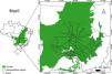
MethodsStudy areaOur study area spans the paved road verge areas within the states of Minas Gerais (MG) and Goiás (GO) (including the Federal District - FD) (MMA, 2023; Fig. 1). The Cerrado vegetation in this region ranges from open grasslands to dense woodlands and shrublands (Eiten, 1972). The mean annual temperature in the study region varies from around 22 °C–26 °C and with an average annual rainfall ranging from 1000 to 1600 millimeters, with more than 70% of the rains occurring between November and March (Ab’Sáber, 2003; Alvares et al., 2013). The dominant soils of the region are Oxisols, with poor nutrient availability and moderate to strong acidity (Lopes and Cox, 1977; Araújo and Haridasan, 1988).
Road selection and road verge buffers
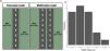
We accessed the road shapefile database of 2022 from the Infrastructure and Transport Federal Department’s website (https://www.gov.br/dnit/pt-br/assuntos/planejamento-e-pesquisa/dnit-geo). We filtered paved roads, and we categorized them into two groups: multi-lane roads, which are approximately 40 meters wide, and two-lane roads, which are approximately 15 meters wide (Fig. 2).

(a) Schematic view of the two-lane and multi-lane roads, along with the buffer width allocated on each road verge side. (b) Frequency distribution of the widths of the areas covered with native vegetation along the roads in the states MG and GO (FD) based on remote sensing analysis of 100 randomly selected road sections.
Under Brazilian federal land allotment legislation (Federal Law 6.766/1979), road verges must maintain a setback of 15 meters on each side of the road, often covered with native plants to promote environmental conservation. However, our field observations revealed considerable variation in the width of these vegetated areas, likely influenced by differences in local land use, road construction practices, and management policies. To accurately quantify these variations and establish a suitable buffer width for our study, we measured, using remote sensing, 100 randomly selected road sections across the two states. The analysis revealed an average vegetated width of 27 meters (Fig. 2), exceeding the minimum legal requirement. Based on these findings, we adopted a 30-meter buffer as the standard for our study, ensuring it encompasses the typical extent of vegetation while providing a consistent framework for ecological assessments (Fig. 2).
Google Earth Engine data source, processing, and sample selectionWe used satellite imagery (Sentinel-2 MSI (MultiSpectral Instrument) Level 2A) to categorize land use classes. We accessed Sentinel-2 (10-meter resolution) with Google Earth Engine (GEE) (Gorelick et al., 2017) from January to July of 2017, 2020, and 2023. For each year, we obtained a single mosaicked image, using the composite algorithm to select and average (using median values) cloud-free pixels.
We cropped the images to our study area and performed a land cover classification over three land use classes: native vegetation, roads, and other human uses (that included agricultural land, pastures, and bare soil). Our ground control point (GCP) dataset consisted of 3,600 points distributed across the three land use classes selected from the high-resolution data from Google Earth 2023. We additionally included 100 points for native vegetation for which we have ground information.
Land use classification and land use change detectionWe used the Random Forest algorithm for our land use classification (Zhang and Yang, 2020). In the context of GEE-based classification using Random Forest, five key variables must be configured: the number of decision trees, maximum leaf nodes per tree, randomization seed, input fraction per tree, and the number of variables per split. In our study, we set the number of decision trees to 10, the input fraction per tree to 0.8, and left the remaining parameters at their default values.
To maximize the accuracy of the land classification, we used Sentinel-2 MSI spectral bands BLUE, GREEN, RED, and two vegetation indices: the normalized difference vegetation index (NDVI) and the soil-adjusted vegetation index (SAVI) to enhance our land use classification (Xue and Su, 2017). NDVI serves as a vital indicator of vegetation cover and greening, and SAVI, on the other hand, is a vegetation index designed to reduce the influence of soil brightness by incorporating a soil-brightness correction factor.
We obtained land use maps for the study area in 2017, 2020, and 2023. We allocated 80% of the GCP dataset for training a Random Forest classifier. Subsequently, we assessed classification accuracy against the remaining 20% of the GCP, achieving an overall accuracy of 75%.
We evaluated the accuracy of the Random Forest classification using the overall classification accuracy and the Kappa coefficient (He et al., 2022b). We found that the overall classification accuracy rates were 73% in 2017, 74.26% in 2020, and 75% in 2023. Importantly, all Kappa coefficients exceeded 0.60, indicating that the classification process was both effective and precise. We calculated the land use change over the periods (2017 – 2020 – 2023) by calculating the area that had changed in the period considered.
Aboveground biomass and carbon stock estimationTo estimate the aboveground carbon stock, we used data from 1,663 trees sampled across 100 plots (50 m × 10 m each) established in areas of native Cerrado vegetation along road verges, across four regions: 18 plots in northwest Goiás (15º58’29” S, 50º06’18” W, along the GO-164, GO-070, and GO-060 highways), 29 plots in southern Goiás (18º16’55” S, 49º14’38” W, along the BR-153), 13 plots in southeastern Goiás (17º42’13” S, 48º09’31” W, along the GO-330, GO-213, and BR-490 highways), and 40 plots in the Triângulo Mineiro and Alto Paranaíba region of Minas Gerais (18º49’04” S, 47º32’17” W, along the MG-190, MG-223, BR-365, and BR-352 highways) (Rios et al., 2023). A minimum distance of 1 km was maintained between plots to ensure spatial independence. Areas with forests, an absence of vegetation, or high levels of degradation with little to no arboreal vegetation were excluded. For more methodological details see Rios et al., 2023.
We calculated the aboveground biomass (AGB) of each sampled tree using the allometric formula developed by Ribeiro et al. (2011): ln B = −3.352 + 2.9853*lnD+1.1855*lnWD, where B is aboveground biomass in kg; D is the diameter at breast height in cm, and WD is the wood density in g cm−3. Subsequently, we extrapolated the value from our calculation to the total area of the road verges covered by native vegetation. For the carbon stock, we assumed that 50% of AGB of each tree is represented by carbon (Chave et al., 2005).
Statistical analysisWe used a linear model to evaluate the differences in the amount of native vegetation between regions, road types and to evaluate if the amount of native vegetation was increasing, decreasing, or remaining stable over time (from 2017 to 2023). The percentage of native vegetation cover was the response variable, while the predictors included region, road type and year as a covariate. The analysis was performed in R version 4.4.1 (R Core Team, 2024).
ResultsCurrent road and road verge extensionWe found 24,566 kilometers of paved roads within the study region, of which 12,975 km were in Minas Gerais (MG) and 11,590 km in Goiás (GO) (including the Federal District - FD). Most paved roads (84.2%) were two-lane roads (totaling an extension of 20,689 km). Considering a buffer of 30 meters on each side of the road, road verges amount to a total area of 147,399 ha (of which 77,848.47 ha in MG and 69,550.42 ha in GO and FD).
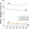
Land use cover and total of sequestered carbon in the native vegetationIn total, 32.08% of the area of the road verges was covered by native vegetation, while the remaining area (67.92% or ca. 150,000 ha) had been converted into anthropogenic land uses before 2023. Two-lane roads had comparatively more native vegetation than multi-lane ones (33.1% versus 25.1%; F1,7 = 914.11, p < 0.001; Fig. 3). Similarly, in total, MG had comparatively more native vegetation along road verges than GO and FD (35.4% vs 28.6%; F1,7 = 14.30, p = 0.007), notably along the two-lane roads (Table 1; Fig. 3). Overall, the amount of native vegetation cover along road verges remained relatively stable through the study period (from 2017 to 2023) and this was true in both states and in the two types of roads (F1,7 = 1.23, p = 0.30; Fig. 3).

Road extension, road verge area, percentage of native cover, and total of carbon stock for the whole sampled area and the respective states according to road type.
| Road extension (km) | Road verge area (ha) | Native vegetation cover (%) | Sequestered carbon (ton) | |
|---|---|---|---|---|
| Total | 24,566.50 | 147,398.90 | 32.1 | 600,714.26 |
| Two-lane road | 20,689.20 | 124,135.10 | 33.1 | 521,857.44 |
| Multi-lane road | 3,877.30 | 23,263.80 | 25.1 | 73,536.01 |
| Minas Gerais | 12,974.70 | 77,848.50 | 35.4 | 348,888.95 |
| Two-lane road | 11,481.20 | 68,887.20 | 36.5 | 318,320.86 |
| Multi-lane road | 1,493.60 | 8,961.30 | 23.8 | 27,001.11 |
| Goiás (including DF) | 11,591.70 | 69,550.40 | 28.6 | 251,825.31 |
| Two-lane road | 9,208.00 | 55,247.90 | 29.1 | 203,536.58 |
| Multi-lane road | 2,383.80 | 14,302.50 | 25.7 | 46,534.90 |
Based on the tree inventory data, we found that the average tree aboveground biomass along road verges is 25.32 tons per hectare, whereas the average aboveground carbon stock amounts 12.66 tons per hectare. When extrapolating these values to the total area covered by native vegetation, we determined that road verges collectively store more than 600,000 tons of carbon in existing native vegetation (Table 1). Given the observed differences in vegetation cover between states and road types, we found that the carbon stored along two-lane roads is 7.04 times greater than that along multi-lane roads, whereas there is 1.40 times more carbon stored along the roads of MG compared to those of GO and FD (Table 1). The carbon lost by 67.92% of already converted land before 2023 is estimated to be 3.8 million tons.
DiscussionIn our study region, approximately 47,000 hectares along road verges are covered with Cerrado vegetation, whereas 150,000 hectares have already been cleared. We estimate that the area with native vegetation currently stores nearly 600,000 tons of carbon. On the other hand, we estimate that nearly 3.8 million tons of carbon was released into the atmosphere prior to 2023 as a result of the vegetation clearing along road verges. Although the current carbon storage falls short of the capacity required by law for the entire surveyed road network, it is crucial to recognize that the remaining vegetation patches, representing 32% of the total, have persisted without deliberate intervention from federal or state authorities. This resilience can probably be attributed to the native plant species of the Cerrado, which are adapted to a seasonal climate, dystrophic soils, and recurrent disturbances by fire (Vasconcelos et al., 2014; Pilon et al., 2021). Moreover, we observed a relatively stable trend in native vegetation cover along road verges, indicating that these areas may even have the potential to recover if law enforcement is implemented effectively or through restoration efforts (Fernandes et al., 2018).
In the plots surveyed, we found that on average these road verges can hold around 12.66 tons of carbon per hectare. Despite being highly disturbed areas, our findings are not that far from previous studies that evaluated carbon stock in different Cerrado physiognomies (Bustamante et al., 2012; Zimbres et al., 2021; Terra et al., 2023), indicating the high potential of these areas to provide ecosystem services comparable to more preserved Cerrado sites. Furthermore, it is important to consider that our estimate of carbon stock results solely from the aboveground biomass of tree individuals. If we consider the amount of carbon stocked belowground (in roots and soil organic matter), these areas have an even greater potential for carbon storage (Dionizio et al., 2020; Terra et al., 2023). Soil alone can hold around 73% of the carbon found in a given area (Terra et al., 2023). Additionally, the above:below carbon ratio in the Cerrado shows nearly five times more carbon below- than above-ground (Terra et al., 2023). By maintaining native vegetation along road verges, these areas not only contribute to carbon sequestration but also support biodiversity, regulate water cycles, and prevent soil erosion, emphasizing their multifunctional role in ecosystem sustainability.
It is important to emphasize that we are not promoting afforestation in the Cerrado to enhance carbon storage. The Cerrado is renowned as the world's richest savanna, primarily due to the high diversity of its herbaceous layer (Myers et al., 2000; Overbeck et al., 2022). Therefore, afforestation in an ecosystem that is traditionally open should be regarded as concerning (Veldman et al., 2015). What we aim to highlight is that the effective conservation and management of the native vegetation along Cerrado´s road verges can contribute not only to biodiversity conservation but also to the maintenance of carbon stocks, notably the often overlooked belowground carbon stock. In this sense, the recent legislative change (Law No. 13.913/2019), allowing the municipalities and districts to reduce road verge width from 15 meters to only five meters, is of high concern. This reduction, which can be implemented in any Brazilian state, not only reduces the physical space available but also significantly undermines the capacity of these areas to provide the critical ecological benefits outlined above.
When considering the two administrative regions under study, it becomes evident that roads within the Cerrado domain in MG boast higher coverage of native vegetation and, consequently, carbon, compared to roads in GO (including the Federal District). Although both regions may, to some extent, regulate the use of road margins for other purposes (Goinfra, 2023; DER, 2023), differences in law enforcement concerning these issues may persist, potentially accounting for such disparities, although they remain speculative.
Apart from road verge areas, recent findings from the Cerrado Deforestation Alert System (SAD Cerrado, 2024; IPAM, 2023) highlight the deforestation crisis within the Cerrado biome in 2023. Notably, MG and GO are among the states experiencing the most extensive loss of native vegetation. By the end of September 2023, MG had already lost more than 46,200 hectares of Cerrado, whereas GO reported even higher rates, with native vegetation area loss exceeding 50,300 hectares (SAD Cerrado, 2024; IPAM, 2023).
Another pressing concern is the high concentration of native vegetation area loss alerts on private lands in MG and GO. Over 80% of deforestation occurs on these lands, with more than 60% affecting savanna landscapes (SAD Cerrado, 2024). Road verges, often owned and managed by a limited number of stakeholders including public entities like local governments and highway organizations, are crucial but underutilized for conservation efforts (Fernandes et al., 2018; DNIT, 2022). Their accessibility presents a strategic opportunity to enhance conservation endeavors.
Challenges and opportunitiesDespite the high potential of vegetation along road verges in the Cerrado, numerous challenges must be addressed concerning the conservation and restoration of these areas. From a biological perspective, careful planning is imperative for restoration to avoid unintended negative consequences, such as the spread of invasive species, and to ensure that native plant species well-adapted to the local ecosystem are selected (Phillips et al., 2020a). Furthermore, road verges are frequently subjected to human activities like illegal logging, poaching, and littering, making effective management and prevention crucial for successful conservation efforts and necessitating the involvement of multiple stakeholders (Nemec et al., 2021).
Financially, conservation and restoration efforts demand significant resources, and securing funding for long-term projects can be particularly challenging, especially in regions with limited financial means. Additionally, when financial support is available, competing priorities compel governments to make strategic investment decisions (Nemec et al., 2021). This underscores the complexity of managing road verges and highlights the need for collaborative efforts and strategic planning to overcome these challenges and ensure the long-term sustainability of Cerrado ecosystems.
Given the costs and challenges associated with conserving and restoring Cerrado road verge vegetation, we recommend a few next steps that we believe are easier to implement. Firstly, we advocate for the implementation of Integrated Road verge Vegetation Management (Bernes et al., 2017; Nemec et al., 2021), a strategy already employed in other countries. This plan can establish a framework for preserving these areas, particularly against illegal activities and improper management practices. Such initiatives may involve leveraging existing law enforcement mechanisms and incorporating adjacent landowners to recognize the benefits of maintaining native areas near their lands.
Furthermore, considering the current and future potential of these areas in storing native vegetation and carbon stock, implementing REDD + and robust payment for ecosystem services programs would also be vital in reducing deforestation rates in the biome (da Conceição Bispo et al., 2023) and avoiding further carbon emissions into the atmosphere. As restoration of the degraded area (i.e., almost 70% of the area without native cover) might be costly and unachievable, another step involves establishing an initiative to strategically identify road verge hotspots (Lewis et al., 2023) that can connect native Cerrado remnants, thereby facilitating focused restoration efforts and biodiversity maintenance.
CRediT authorship contribution statementMA: conceptualization, methodology, validation, formal analysis, investigation, data curation, writing - Original Draft, writing - Review & Editing, and funding acquisition; HLV: conceptualization, formal analysis, resources, data curation, writing - Review & Editing, supervision; VSV: data curation, writing - Review & Editing; IOM: conceptualization, methodology, validation, data curation, writing - Review & Editing, supervision and funding acquisition.
FundingFinancial support was provided by CAPES (Coordenação de Aperfeiçoamento de Pessoal de Nível Superior, Brazil – Financial Code 001), CNPq (Conselho Nacional de Desenvolvimento Científico e Tecnológico, grant 441142/2020-6), and the Agence Nationale de la Recherche under the "Investissements d'avenir" programme (France government, grant ANR-10-LABX-04-01).