


Changes in the structure of natural habitats surrounding Protected Areas interfere with biodiversity conservation measures. The goals of this research were to analyze the fragmentation and loss of vegetation in three landscape levels surrounding Passo Fundo National Forest, RS, Brazil, in 1986, 1997, and 2011, and to identify the degree of isolation/connectivity of these patches. These analyses were based on landscape metrics, in levels of classes and patches. The area occupied by vegetation increased for three landscape levels, from 1986 to 2011, accompanied by a reduction of the distances between remnants of the forest. Forest coverage was higher in the Protected Area in the other two levels of landscape. This scenario suggests a reduction of agricultural expansion in the region and an attenuation in the process of habitat loss and fragmentation. However, the current proportion (19%) of vegetation outside the Protected Area is still critical for many species.
Fragmentation and habitat loss as a result of agriculture and urban expansion are considered the greatest threats to biodiversity (Fahrig, 2003; Laurance and Bierregaard, 1997). The fragmentation process causes changes in the spatial arrangement and ecological processes of communities (Saunders et al., 1991). This results in remnants of natural habitats where the size, complexity of shape, distance, and critical threshold of connectivity can threaten biodiversity and lead to an abrupt extinction of species (Andrén, 1994; Metzger and Décamps, 1997).
A measure enacted in Brazil to limit or reduce biodiversity loss, ensuring the maintenance of natural vegetation remnants and avoiding the effects of fragmentation, was the creation of Protected Areas (PAs) and Buffer Zones (BZs) surrounding protected areas within the National System of Conservation Units (SNUC – Law 9.985/2000) (Brasil, 2004).
The function of the buffer zones and ecological corridors is to ensure connectivity between ecosystems, allowing the maintenance of ecological processes and the flow of species and genes. In addition, buffer zones and ecological corridors protect the Protected Areas (PAs) from the negative effects of human impact (Brasil, 2004).
Despite these laws, little attention has been given to the planning and management of regions surrounding Protected Areas (Andrew and Defries, 2007; Perelló et al., 2012; Wallace et al., 2005). In Brazil, additional guidelines should include the zones surrounding the Protected Areas in biodiversity conservation policies and specific regulations are required to establish the boundaries of buffer zones (Perelló et al., 2012).
Landscape structure research is instrumental to begin management of regions surrounding Protected Areas, and to explain and understand the effects on ecological processes (Mairota et al., 2012). Analysis of the landscape structure and spatial patterns can answer questions about the composition and arrangement of the structural elements that comprise this landscape (McGarigal and Cushman, 2005). In this respect, various landscape metrics can help to explain the process of fragmentation in terms of the spatial arrangement, the degree of fragmentation, and the degree of isolation of the natural vegetation remnants (McGarigal and Marks, 1995).
In this study we analyzed landscape structure and spatial patterns of the natural habitat (Araucaria forest and grassland) surrounding Passo Fundo National Forest (Flona – PF) in 1986, 1997, and 2011. Flona PF is a sustainable use Protected Area located in Rio Grande do Sul State, Brazil. We addressed the following questions: (a) was there intensification in the process of loss, fragmentation, and isolation of Araucaria forest and grassland, within the Protected Area, in its buffer zone and within the municipal limits surrounding the Protected Area, between 1986 and 2011? (b) What was the degree of connectivity/isolation of the patches of Araucaria forest and grassland within the municipal boundaries surrounding the Protected Area between 1986 and 2011? (c) What were the locations of the more isolated patches of Araucaria Forest within the municipal limits surrounding the Protected Area between 1986 and 2011?
Materials and methodsStudy areaThe study area includes the region surrounding Flona – PF, represented by the borders of seven municipalities (Fig. 1).

The study site is characterized by two geomorphological regions: the Missões Plateau and the Araucaria Plateau (IBGE, 2003), both of which are predominantly plain lands. The climate of the region is classified as Cfa (Köppen classification system), temperate/humid with hot summers, and has an average annual temperature range between 16 and 18°C (Alvares et al., 2013; Camargo et al., 2002).
The original vegetation includes the Araucaria Forest, occupying the greatest area, and the Steppe (IBGE, 2004), appropriately renamed the grasslands of South Brazil (Overbeck et al., 2009). Currently, the total population of these municipalities is 234,037 inhabitants; 184,826 from Passo Fundo (IBGE, 2010).
Natural vegetation mapsThe land cover maps were obtained by visual interpretation of 30 meters resolution Landsat 5 TM images for the years 1986, 1997, and 2011, acquired from the website of the National Institute for Space Research (INPE, 2012). The visual interpretation of images was done by MapInfo 10.0, using compositions 5, 4, and 3 (RGB) and scale 1:50,000. Two field surveys were carried out to guarantee high map accuracy of the 2011 map, which was accessed by the Kappa index (0.88). After the thematic maps’ elaboration, we prepared two maps for the three years (1986, 1997, and 2011). The first map was composed of Araucaria forest fragments in different successional stages and the second map was composed of wetlands (humid area) and grassland, which were grouped into a single class of grasslands. We eliminated patches from the maps smaller than 1.0ha.
Each vector format map was converted to raster format by the method of assigning cell values using cell centers in ArcGIS 9.3 software, which were then imported into Fragstats 4.1 to calculate landscape metrics.
Analysis of habitat loss and fragmentation and connectivity/isolationFor these analyses, class level metrics were selected: PLAND (Proportion of landscape), AREA_MN (Mean patch area-ha), and ENN_MN (Mean Euclidean nearest-neighbor distance). These metrics on class level were estimated for three landscape levels: within the Protected Area (PA), in its Buffer zone (BZ), and in the entire study area, i.e. within the municipal boundaries (Fig. 1), in the years 1986, 1997, and 2011.
To analyze the degree of isolation of the grassland and forest patches, we used the ENN (Euclidean nearest-neighbor distance) patch level metric, only for the total study area (municipal boundaries). Distances between the fragments of forest were presented in maps for the three study years. The distances between patches of grassland were shown in graphs. We used PAST software to perform a Kruskal–Wallis test to determine differences between patch isolation distances in the three analyzed years (1986, 1997, and 2011).
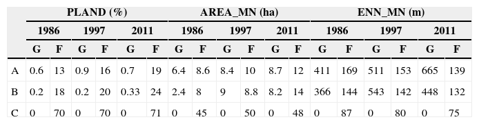
ResultsAnalysis of fragmentation and loss of habitats and connectivity/isolation in three landscape levels during 1986–2011The area occupied by forest was higher than the grassland, within the three landscape levels, in the three years of research (Table 1). Within the PA, no grassland patches were found, only in Araucaria forest, which varied little from 1986 to 2011 due to the Protected Area Management Plan.
Metrics calculated for grassland and forest patches in the three landscape levels, in 1986, 1997, and 2011.
| PLAND (%) | AREA_MN (ha) | ENN_MN (m) | ||||||||||||||||
|---|---|---|---|---|---|---|---|---|---|---|---|---|---|---|---|---|---|---|
| 1986 | 1997 | 2011 | 1986 | 1997 | 2011 | 1986 | 1997 | 2011 | ||||||||||
| G | F | G | F | G | F | G | F | G | F | G | F | G | F | G | F | G | F | |
| A | 0.6 | 13 | 0.9 | 16 | 0.7 | 19 | 6.4 | 8.6 | 8.4 | 10 | 8.7 | 12 | 411 | 169 | 511 | 153 | 665 | 139 |
| B | 0.2 | 18 | 0.2 | 20 | 0.33 | 24 | 2.4 | 8 | 9 | 8.8 | 8.2 | 14 | 366 | 144 | 543 | 142 | 448 | 132 |
| C | 0 | 70 | 0 | 70 | 0 | 71 | 0 | 45 | 0 | 50 | 0 | 48 | 0 | 87 | 0 | 80 | 0 | 75 |
A, total study area; B, inside buffer zone; C, inside protected area; G, grassland; F, forest.
PLAND (Proportion of landscape), AREA_MN (Mean patch area-ha), ENN_MN (Mean Euclidean nearest-neighbor distance).
The metrics, Pland and Area_MN, increased for forest and grassland patches from 1986 to 2011 in the three landscape levels. The mean distance (Enn_MN) for patches of grassland increased, within the total study area and within the zone of buffer, but decreased for the forest patches, in three landscape levels from 1986 to 2011.
The forest percentage (Pland) and the mean areas of the patches (Area_MN) were higher within the Protected Area, than in the other two landscape levels (BZ and the total study area). However, the ENN_MN was lower within the Protected Area than in the other two landscape levels, in 1986–2011.
Degree of isolation and spatial distribution of patches within of total area of study in 1986, 1997, and 2011The distance (ENN) between the grassland patches also increased over the three years of research, in the total study area (Fig. 2). There was a significant difference (p<0.05, H=25) between the isolation distances (Fig. 2).

There was reduction in the distance (ENN) between the forest patches (Fig. 3) and a significant difference (p<0.05, H=153) between the distances, over the three years of investigation. Fig. 3 covers both forest patches, which are within the Protected Area, such as the patches of buffer zone and those outside the buffer zone.
Discussion
The area occupied by forest and grassland was higher in 2011 than in 1997 and 1986 in the three landscape levels. This demonstrates a reduction in the process of loss these natural habitats around Flona – PF over the study period. This increase in natural vegetation is related to a reduction in agricultural areas reported by Benetti (2010) in the northern half of the state of Rio Grande do Sul between 1985 and 1998. Lira et al. (2012) also found an increase of natural areas in different stages of regeneration in the Atlantic Forest between 1960 and 2000. Navarro and Pereira (2012) and Mather and Needle (1998) detected the same trend in European regions.
Nevertheless, the 19% of natural vegetation within the total study area is considered a critical proportion to meet the survival needs of various species. Rybicki and Hanski (2013) and Andrén (1994) suggest that less than 20% of the total area of a landscape may represent an increased risk of extinction for many species.
The increase in the AREA_MN of grassland and forest over the study period also suggests an attenuation of the fragmentation process in the three landscape levels. However, the mean areas found in the buffer zone and within the total study area, in 2011, are still small fragments, with mean areas of 12 and 14 hectares, respectively.
Small fragments have a dichotomous role in altered landscapes. Although they occupy a small fraction of the total landscape and are subject to greater edge effect (Murcia, 1995), these fragments develop an important role as a stepping stone in fragmented landscapes. Boscolo and Metzger (2011) found that small habitat patches and linear fragments are a mechanism of functional connectivity between large areas of habitat and also in landscapes with intense human activity.
However, Gibson et al. (2013) found a high rate of extinction of small mammals in forest fragments of less than 10ha in Thailand and also the presence of an invasive species of rodent (Rattus tiomanicus) in all forest fragments studied. For Gibson et al. (2013), the apparent synergism between habitat fragmentation and invasive species reinforces the dire need to maintain large fragments of natural vegetation in the landscape.
The reduction in mean distance of forest patches indicated an improvement in the structural connectivity between the patches of forest, in three landscape levels, likely due to the increased forest cover found in 2011. This result corroborates those found by Lira et al. (2012) in the Atlantic Forest. Unlike forest, the distance between patches of grassland increased due to the emergence of new patches of grassland, within the BZ and south of the total study area, indicating the regeneration of grassland.
With the analysis of the metrics, on class level, between the three landscape levels, we can see that Protected Area has the highest coverage of forest, larger patches, and also the smallest isolation distances than the other two landscape levels (BZ and the total study area).
The reduction of 71% of forest cover, within the Flona, in 2011 to 24%, in BZ, and 19% in the total area of study, indicates that the immediate surroundings of Flona PF are widely occupied by human activities, as reported by Joppa et al. (2008) for surroundings of Protected Areas of the Atlantic Coast. According to the author, at least 50% of the immediate surroundings of these Protected Areas are occupied by human activities, resulting in highly fragmented natural areas, but with connectivity potential.
The analysis of the connectivity/isolation between each forest patch, within the total area of study, shows that closer to the Protected Area the patches are less isolated, with distances between 60 and 300m. This indicates that, despite the lower proportion of forest outside the Flona, the distribution of patches near the Protected Area show a connectivity potential in some local landscapes, especially at the limits of its buffer zone (Fig. 3). The more isolated patches of forest are the most distant from the PA, occurring mainly in plain topographic regions.
ConclusionsThe analysis of vegetation showed a tendency toward decreasing fragmentation and loss of natural habitats, as well as the reduction in the average distance between forest patches, in the three levels of landscape, over the years of this study. However, the current proportion of vegetation in the total landscape investigated, mainly, may still be compromising for many species.
The Protected Area maintains the highest proportion of Araucaria forest and the larger patches of all landscape investigated and is essential for conservation of regional biodiversity. In addition, the distribution of fragments outside the PA, along with the patches of PA, show a connectivity potential, due to lower distances of isolation observed in the immediate surroundings of the PA.
We recommend the adoption of measures of maintenance and restoration of forest and grassland in the nearest surroundings and in the more distant Flona, in order to increase the natural habitats in the region and improve structural and functional connectivity of the landscape.
Conflicts of interestThe authors declare no conflicts of interest.
We thank CAPES (Coordination for the Improvement of Higher Education Personnel) for the financial support of this research.

