


Identifying and mapping strategic areas for conservation and restoration actions are essential initiatives to reduce human impact on biodiversity. However, most spatial prioritization does not involve decision-makers and stakeholders, generating a science-application gap. Here, we describe a participatory framework to map strategic areas for conservation of 27 species and their ecosystems (SASC), and strategic areas for ecosystem restoration (SAER) in a highly diverse region of Bahia, Brazil. We had eleven participatory meetings where scientists, decision-makers and stakeholders discussed and agreed with the project and methodology. The participants chose five prioritization criteria: habitat amount, environmental suitability, fire frequency, permanently protected area amount and diversity of phytophysiognomies, in this order of relevance. We generated technical maps based on these criteria, which were adjusted to 11 SASC and 12 SAER, according to participants’ perspectives. Many decisions taken during this process would hardly be taken in a conventional academic prioritization process, as some demands arose from participants. These maps are the first step for many posterior conservation actions (e.g. reducing agricultural impacts and species trade), therefore, the results were made accessible to the general public. This process provided participants a sense of ownership of the knowledge, as they became active agents in the process.
There are several human activities that threaten biodiversity and ecosystem integrity (Díaz et al., 2019). The intensity and importance of each threat vary locally, depending on the biodiversity composition, and the socio-economic and political factors in the assessed region (Loyola et al., 2018; Pimm et al., 2014; Strassburg et al., 2019). In this sense, to conserve biodiversity and obtain the benefits from its ecosystem processes, it is essential to identify and map strategic areas to implement conservation, restoration, and management actions (Akçakaya et al., 2018; Pimm et al., 2014; Strassburg et al., 2019).
The mapping of environmentally strategic areas is one of the first steps of governmental action and management plans (e.g. ConsórcioGeoBahia et al., 2018; INEMA et al., 2020; Rocha et al., 2019). Such initiatives usually have short deadlines for elaboration and implementation, multiple goals, and the resources allocated tend to be very limited, especially in developing and low-income countries (Godoy and Leuzinger, 2015). In this sense, it is important that a mapping of strategic areas adopt: (i) a low-cost, efficient, and quick methodology; (ii) well-defined goals; and (iii) a participatory approach, adaptative to the local reality. While there are many prioritization studies with great technical contribution (e.g. Dória and Dobrovolski, 2021; Niemeyer et al., 2020), the non-involvement of decision-makers and stakeholders in these processes creates a science-application gap, precluding academic contributions to subsidize governmental strategies (Bertuol-Garcia et al., 2018). The participatory process during the mapping is essential, as it is at this stage that scientists, decision-makers, and stakeholders discuss the main species threats, the regional conflicts, and the cost of each stage, increasing the chances of a proposed solution to be actually adopted by the government and accepted by the local community (Loyola et al., 2018; Pougy et al., 2015; Strassburg et al., 2019).
The region of Chapada Diamantina and Serra da Jiboia (Bahia, Brazil) are very important areas for conservation, as these regions holds high biodiversity which provide a number of ecosystem services (e.g. carbon stock, water security due to riparian vegetation, and for being one of the regions with greatest tourist interest in the country) (Blengini et al., 2015; Fernandes et al., 2020; Giulietti et al., 1997; INEMA et al., 2020). However, this region and its biodiversity are highly impacted by human activities such as tourism, mining, urbanization, fires of native vegetation, monocultures, cattle, extraction and collection of flora and fauna for cultivation and export (Blengini et al., 2015; INEMA et al., 2020; Martinelli, 2007). Because these regions need urgent conservation and restoration efforts, the Territorial Action Plan for the Conservation of Endangered Species and their ecosystems in the Chapada Diamantina-Serra da Jiboia (PAT-CDSJ) was elaborated, which aims to minimize the pressures of human activities on the regional biodiversity (INEMA et al., 2020). Two of the main conservation targets of this action plan are (i) Critically Endangered (CR) species that are not covered by protection instruments (hereafter CR-Gaps), and (ii) their associated ecosystems.
Here, we provide a successful prioritization framework applied to the PAT-CDSJ, based on a participatory approach. We identified and mapped strategic areas for the conservation of CR-Gap species and their ecosystems (hereafter SASC), and strategic areas for ecosystem restoration (hereafter SAER). The proposed mapping framework was entirely elaborated by scientists, decision-makers, and stakeholders. It includes a low-cost and fast-developing methodology, and can be applied to different regions when adjusted to local objectives and contexts.
MethodsPAT-CDSJ, study area and focal speciesThe PAT-CDSJ is an action plan built by the government of Bahia in a participatory process, including decision-makers, scientists, and stakeholders (INEMA et al., 2020). This document is an instrument that helps to guide public policies and put them into practice. The PAT-CDSJ presents a set of objectives and proposed actions that will solve problems and minimize threats to species and their ecosystems (see details of the PAT-CDSJ document and actions in the Supplementary Material 1). The selection of strategic areas for conservation and restoration was originally requested by decision-makers, who are members of the regional government, involved and responsible for the actions of the PAT-CDSJ. Hence, this study is part of the first action of the PAT-CDSJ and will support its subsequent actions.
The study area considers the limits defined for the PAT-CDSJ, extending between the central and eastern regions of the state of Bahia, Brazil (Fig. 1). The limits include portions of 56 municipalities and cover 3,918,743 ha (INEMA et al., 2020). The objective of the PAT-CDSJ is to develop public policies in unprotected areas, as areas protected are already covered by the law. The Chapada Diamantina occurs mainly in the Caatinga Brazilian domain (i.e. semi-arid vegetation), while Serra da Jiboia falls within the Atlantic Forest Brazilian domain. This region comprises a wide range of climatic conditions, geological formations, soil types, vegetation (Fig. 1 and S1), high diversity and degree of endemism (Giulietti et al., 1997; INEMA et al., 2020). Most of the 27 CR-Gap species (24 plants and three invertebrates, Table S1) of the PAT-DCSJ are endemic to mountain regions of Bahia, Brazil, and low density and scattered populations (INEMA et al., 2020; IUCN, 2022), common characteristics of gap species (Rodrigues et al., 2004).
 and Atlantic Forest (where Serra da Jiboia occurs, green crosshatched). The small polygons within the limits of the PAT-CDSJ (white areas) are protected areas, that are not part of the PAT-CDSJ territory.")
The study area of the Territorial Action Plan for the Conservation of Critically Endangered Species and their Ecosystems of the Chapada Diamantina-Serra da Jiboia – PAT-CDSJ, including municipality divisions, elevation, and the Brazilian phytophysiognomies Caatinga (where Chapada Diamantina occurs, orange crosshatched) and Atlantic Forest (where Serra da Jiboia occurs, green crosshatched). The small polygons within the limits of the PAT-CDSJ (white areas) are protected areas, that are not part of the PAT-CDSJ territory.
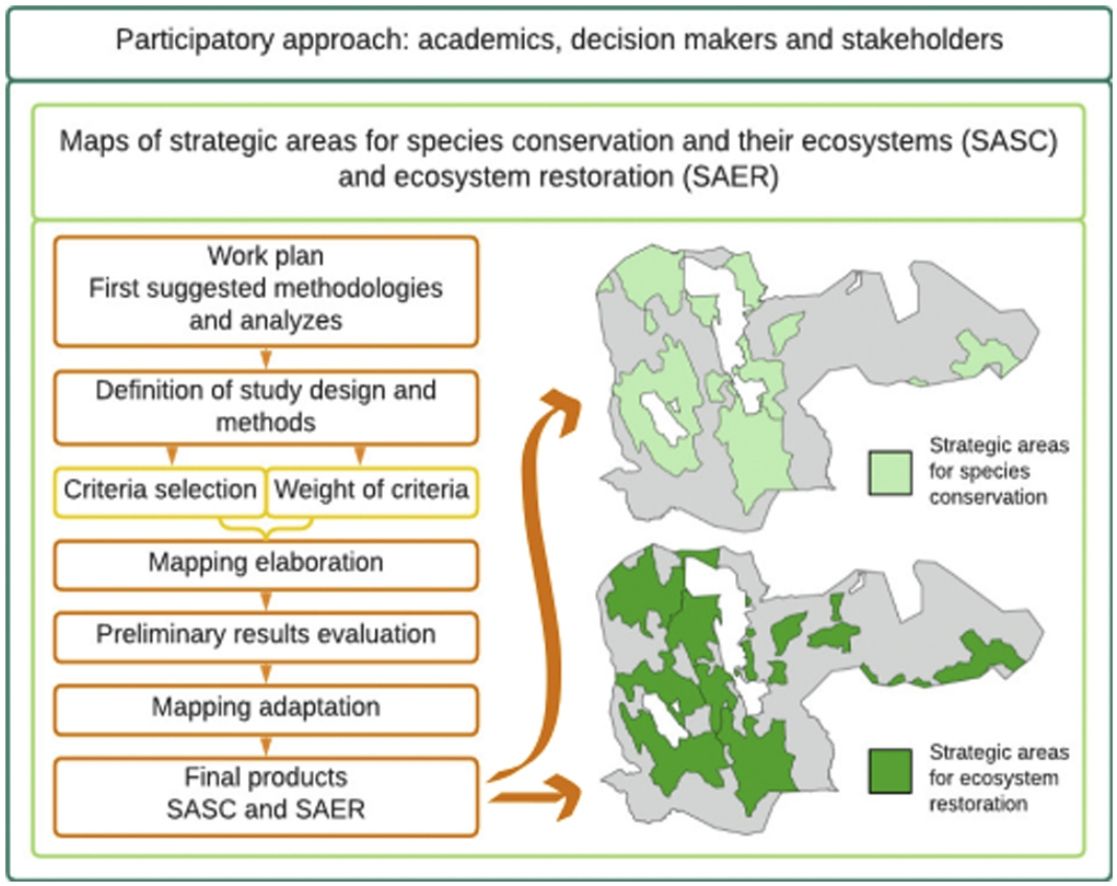
All stages of this study were discussed in several participatory workshops and meetings attended by scientists (from national, state and local universities), decision-makers (i.e. regional government administrators), and stakeholders (e.g. from local NGOs, managers of protected areas close by the PAT-CDSJ limits, and national government members) (Fig. 2, Table S2). In the first meeting, the decision-makers presented the PAT-CDSJ document and their expectations about the mapping action (i.e. SASC and SAER). Subsequently, in the first participatory workshop, the scientist responsible for the mapping suggested a work plan. Using the work plan as a starting point, the participants consensually defined the methodology and the data that should be used, considering local context, data availability, main species threats, project viability, and the relevance and cost of each mapping criterion (see details below). After defining the criteria, the participants assigned weights to each of them.
 and Strategic Areas for Ecosystem Restoration (SAER) of the Territorial Action Plan for the Conservation of Endangered Species of the Chapada Diamantina-Serra da Jiboia (PAT-CDSJ). Technical products generated (dark orange), a brief explanation about each product (light orange), meetings and monitoring workshops (dark green), the purpose of the meetings and workshops (light green), construction workshops (purple), participants (blue), the final product (pink).")
Participatory workflow. Steps and products generated during the participatory mapping process of the Strategic Areas for Species Conservation (SASC) and Strategic Areas for Ecosystem Restoration (SAER) of the Territorial Action Plan for the Conservation of Endangered Species of the Chapada Diamantina-Serra da Jiboia (PAT-CDSJ). Technical products generated (dark orange), a brief explanation about each product (light orange), meetings and monitoring workshops (dark green), the purpose of the meetings and workshops (light green), construction workshops (purple), participants (blue), the final product (pink).
The intention for the work plan was to be inclusive, considering several possible environmental and socioeconomic aspects, so the participants could discuss and decide the better aspects and strategies. Among all the possible favorable and unfavorable aspects for the mapping, the objective of the work plan was to reach a reduced number of criteria for the selection of areas. For example, regarding the planning units, participants discussed whether to consider the planning unit as a regular polygon (e.g. hexagons) or microbasins, and which microbasin level would be adopted. Regarding the criteria, the participants discussed several possibilities of landscape metrics (e.g. amount of habitat, connectivity, distance between fragments), human pressures (e.g. proximity to mining areas, fire frequency, type and proximity of agricultural areas), and proximity to Permanently Preserved Area (APP, Portuguese acronym) and protected areas. All participants had to justify why or why not each decision of the methodological choice was made.
The scientist responsible for the mapping, then, gathered all data to develop the mapping – partly compiled by online databases (e.g. occurrence records and environmental variables), partly provided by the regional government members (e.g. limits of the PAT-CDSJ and APP), and partly provided by the other scientists (e.g. occurrence records and phytophysiognomy classification). The scientist responsible also developed all technical procedures for mapping, however, most steps were assisted by other scientists and decision-makers in brief meetings. For example: (i) the scientist responsible compiled occurrence records from databases and the taxonomists validated them, and (ii) the scientist responsible proposed an APP design and a geography technician from INEMA validated the proposal and provided additional data (see all details in the subsections below).
The preliminary mapping was presented in a second participatory workshop, where all participants gave suggestions to the final mapping. The SASC and SAER mapping were also presented and discussed in two monitoring workshops of the general PAT-CDSJ project, where the progress of the other actions was also presented by other scientists or decision-makers responsible. Finally, the new mapping proposal was presented to the decision-makers, then, sent to all participants for suggestions and final approval.
Mapping criteriaWe considered four and five criteria to define the areas of conservation and restoration, respectively (see details in Supplementary Material 1). In this order, the most relevant criteria were: ‘Habitat amount’, ‘Environmental suitability’, ‘Fire frequency’, ‘Permanently Preserved Area amount’ (this one was used only for SAER), and ‘Diversity of phytophysiognomy’. As the planning units (PUs) used to evaluate each criterion, we chose the microbasin limits established by National Hydrographic Division, level 6 (ANA, 2015), dividing the PAT-CDSJ into 314 Pus – planning unit definition often used in other established public policies and because it can also be a natural ecological barrier for some species or populations of animals and plants (e.g. Loyola et al., 2018; Monteiro et al., 2018).
Habitat amountWe used data from the MapBiomas Project, collection 5.0, 250 m resolution (Mapbiomas, 2019) to quantify the habitat amount per PU (i.e. the percentage of native vegetation cover). We reclassified the data so that all pixels referring to native vegetation were equal to 1, and anthropized areas to 0 (Fig. S2). For the SASC mapping, we considered that the greater the habitat amount of a PU, the more relevant it is. For the SAER mapping, we defined the relevance of the PUs considering the percentage of vegetation cover, based on the extinction threshold hypothesis (Andrén, 1994), where PUs with intermediate values of habitat amount were considered more relevant than the ones with extreme values (i.e. the most relevant values range from 20% to 40%, while the least relevant were 0% and 100%, see Supplementary Material 1 for details). In addition, to incorporate landscape connectivity into the mappings (important for the maintenance of biological flows; Pascual-Hortal and Saura, 2007), we calculated the habitat amount of the neighboring PUs surrounding the target PU and used their average as a weight for the target PU habitat amount (Fig. S3, see Supplementary Material 1 for details).
Environmental suitabilityWe compiled occurrence records from online databases and refined the records removing duplicates, spatial bias (i.e. coordinates closer than 1 km apart), and outliers (e.g. coordinates on the sea). We used as environmental layers a subset of bioclimatic variables (average between 1979 and 2013), altitude, and soil quality, at 30 arcsec (c.a. 1 km from the Equator) resolution (Table S3). For species with more than 20 occurrence records, we generated a consensus model based on Bioclim, Maximum Entropy, Generalized Linear Model, Random Forest, and Support Vector Machine. For rare species with few occurrence records, we used the Euclidean Distance, which estimates environmental similarity (Siqueira et al., 2009; Vilela et al., 2018) (see Supplementary Material 1 for details).
Fire frequencyWe compiled the fire records from Queimadas Program (INPE and LASA, 2020), from 2017 to 2020, and counted the records inside of each PU (Fig. S4). We normalized the results between 0 and 1, in which PUs with greater amounts of fire records (closer to 0) were considered less relevant for the mapping of SASC and SAER. Fires frequency in the PAT-CDSJ region is worrying and identified by local government documents as one of the main threats to local biodiversity (Blengini et al., 2015; INEMA et al., 2020). The participants (especially the ones related to the local NGOs, regional government members and environmental managers) also highlighted the high frequency of fire events in the region, mostly due to intensive agriculture. They suggested that the fire frequency could be a proxy of high human activity. Therefore, the higher concentration of fire frequency in a PU, the higher the cost of implementing conservation and restoration actions.
Diversity of phytophysiognomyEnvironments with greater habitat heterogeneity are expected to have higher species diversity, and greater resilience and resistance to impacts (Fahrig et al., 2021; Machado et al., 2013). Because habitat heterogeneity can be translated into phytophysiognomy diversity (Machado et al., 2013), we estimated the phytophysiognomy diversity for each PU through the Shannon Diversity Index, in which the greater the phytophysiognomy diversity of a PU, the greater its relevance. We used the mapping of phytophysiognomies elaborated by SEMA-BA and INEMA-BA (ConsórcioGeoBahia et al., 2018) (Fig. S1), considering only the natural vegetation. Because the PAT-CDSJ limits include Atlantic Forest and Caatinga and, in its limits specifically, the Caatinga naturally has greater diversity of phytophysiognomies, we normalized the results separately for the two domains (Fig. S5) to avoid biasing the map towards one domain.
Permanently Preserved Area amount (APP, Brazilian acronym)APP is “a protected area, covered or not by native vegetation, with the environmental function of preserving water resources, landscape, geological stability, and biodiversity, facilitating the gene flow of fauna and flora, protecting the soil, and ensuring the well-being of human populations” (Brasil, 2012). The APP amount criterion was used only to define SAER, as APPs have lower conflicts of interest with the local community (lower cost) since they should already be protected. The only available data for APP are (i) slope (data not publicly available; INEMA-BA), and (ii) areas declared by landowners (State Forestry Registry of Rural Properties; GeoBahia, 2021a). However, not all landowners declared their APPs and most of them refer only to the regions along rivers (for definitions of APP limits see Brasil, 2012). To complement the available data, we added the shortest distance suggested by the legislation (i.e. 30 m) along rivers (GeoBahia, 2021b). We joined this result to the available data to better approximate the real value of APP (Fig. S6) and calculated the percentage of the composed APP area for each PU.
Assignment of weights and evaluation of multi-criteriaThe criteria listed above do not necessarily have the same relevance for the SASC and SAER mappings. To define the relevance, we used the method Analytic Hierarchy Process (AHP) – commonly used in Brazilian action plans (e.g. ConsórcioGeoBahia et al., 2018; Rocha et al., 2019) – which compares pairs of criteria according to the fundamental scale of Saaty (1977) (see Table S4).
To achieve the consensus among the participants during the workshop, the AHP was applied by panel cards (Fig. S7). First, we discussed the relevance of criteria for both mappings (SASC and SAER), separately. Then, each criterion was exposed in a panel and the participants ranked their relevance, based on theoretical grounds and application feasibility. Subsequently, all participants consensually assigned weights to each criterion. To estimate the consistency among the weights, we calculated the Consistency Ratio (see details in the Supplementary Material 2), where values near 1 indicate low consistency and near 0 indicate high consistency (Saaty, 1980). Then, we considered ratios below 0.1 as consistent to validate the weights assigned. Finally, we multiplied each standardized result (i.e. normalized criteria from 0 to 1) by its weight. All weighted criteria were then summed to generate a single result for each species, according to the equation:
where Rn refers to the result of each species n, Ri is the result for each criterion i, and ωi is the associated weight attributed to the criterion i. The 27 maps (one for each species) were normalized, ranging from 0 (relevant) to 1 (highly relevant).
We defined the order of criterion relevance for SASC (except for item 4) and SAER mapping, as follows: 1) Habitat amount, 2) Environmental suitability, 3) Fire frequency, 4) APP amount, and 5) Diversity of phytophysiognomy. The criterion 1 was the most relevant because the presence of habitat is determinant for species occurrence. Criterion 2 came in sequence, as the environmental suitability is determinant for species persistence, followed by criterion 3, as it is one of the main threats to local species (INEMA et al., 2020). For restoration, criterion 4 was chosen considering the importance of maintaining water resources and encouraging compliance with the law. Finally, criterion 5 was the least relevant, as the heterogeneity is important but not determinant for species occurrence and persistence. Once the priority order was raised, each criterion received a weight linked to its relevance.
Strategic areasWe generate two synthesis maps (for conservation and restoration) summing the 27 altimg="si3.svg"Rf -maps, in which the greater the PU value, the greater its relevance. We selected from the synthesis map only the 30% most relevant PUs. According to the decision-makers, this is a viable percentage for the implementation of subsequent public policies, considering the budget available to the PAT-CDSJ.
To select the most relevant PUs, we first considered all PUs with CR-Gap species occurrence records, to ensure that all sites where the species have been found were considered, helping to reduce the gap species in the current protected areas in Brazil (Rodrigues et al., 2004). Next, we selected the remaining PUs with the highest relevance according to all criteria together (i.e. those that no longer had occurrence records). This selection was proportional to Chapada Diamantina and Serra da Jiboia regions. We distinguished the strategic areas based on a set of PUs that were close to each other and within political units. The participants delimited and named the strategic areas according to their knowledge about the socio-environmental characteristic of the region (see details for delimiting and name-giving procedures for strategic areas in the Supplementary Material 1).
ResultsStrategic areasFor both conservation and restoration maps, criteria showed a more dispersed pattern throughout the territory, except for habitat amount criterion in the conservation map, that showed higher relevance mainly around the protected areas (Fig. 3). The synthesis map for conservation showed the same pattern of the habitat amount criterion – as this criterion received the highest weight compared to the others – while for restoration, it showed a more dispersed pattern (Fig. 3). By restricting the result to the 30% most relevant PUs, we selected 86 PUs in the Chapada Diamantina (in which 32 PUs had species occurrence records, Fig. S8) and 8 PUs in the Serra da Jiboia (in which 1 PUs had species occurrence records, Fig. S8). Finally, the strategic area delimitation provided 11 SASC, more concentrated around the protected areas (Fig. 4A, Table S5), and 12 SAER, better distributed across the PAT-DCSJ (Fig. 4B, Table S6).
 for ecosystem conservation (left) and restoration (right) mapping. The relevance of UPs is associated with the cost, presented along the gradient from ‘relevant’ (highest cost) to ‘highly relevant’ (lowest cost). The upper right numbers refer to the weight of each criterion.")
Relevance of UPs by criterion and the synthesis result (i.e. all criteria and species) for ecosystem conservation (left) and restoration (right) mapping. The relevance of UPs is associated with the cost, presented along the gradient from ‘relevant’ (highest cost) to ‘highly relevant’ (lowest cost). The upper right numbers refer to the weight of each criterion.
 (A) and Strategic Areas for Ecosystem Restoration (SAER, 12 in total) (B), including municipality divisions in the Territorial Action Plan for the Conservation of Critically Endangered Species and their Ecosystems of the Chapada Diamantina-Serra da Jiboia – PAT-CDSJ.")
Strategic Areas for Conservation (SASC, 11 in total) (A) and Strategic Areas for Ecosystem Restoration (SAER, 12 in total) (B), including municipality divisions in the Territorial Action Plan for the Conservation of Critically Endangered Species and their Ecosystems of the Chapada Diamantina-Serra da Jiboia – PAT-CDSJ.
Approximately 29 participants attended the two participatory workshops and the two monitoring workshops, while assistance meetings (approximately seven) had fewer participants, with decision-makers always present. The four workshops lasted approximately 4-hs, and the assistance meetings were shorter (∼2-hs). The group of participants was heterogeneous, consequently, during the meetings, some divergent suggestions were exposed, however, we always reached a consensus before moving on to the next step.
In general, while scientists focused on the ideal methods and biological aspects (as most scientists were biologists), the decision-makers and stakeholders focused on the usefulness and feasibility of the map implementation and political aspects. For example, considering that the main conservation target is the CR-gap species, at first, scientists suggested the use of basins as planning units due to natural limits, which is more relevant for biological aspects. Some decision-makers, although, suggested political units (i.e. municipality limits) due to the ease of carrying out public policy actions in these units. Considering both aspects, they decided to use basin limits for the smaller units (i.e. PUs), and aggregate these units considering political limits into strategic areas.
Another example was related to the presentation of the strategic areas. Some scientists suggested presenting all PUs with gradual colors, from the most to the least relevant areas. They argued that even inside of the strategic areas, the gradual design provides the idea of a priority ranking that could guide the order of the implementation of the action plans. However, the decision-makers defended the delimitation of the areas without ranking. The reasons were: (i) a gradual map is not informative, as they already know that the whole region is important – instead of deciding later which are the best areas to implement new actions, they wanted to delimit it to this exact action, (ii) a delimited result is more intuitive to present to other stakeholders and decision-makers, avoiding the misinterpretation that “some of these selected areas are not so important”, and (iii) the beginning of the next actions will be almost simultaneous in all the defined areas, and the order of implementation of the actions will depend especially on the articulation with the local decision-makers. The solution was to keep both results, the gradient maps as a supplement and the delimited SASC and SAER as the final design of the map.
Other important discussions occurred regardless of which group the participants belonged to. For example, they evaluated that most criteria related to human pressures (e.g. mining, agricultural, cattle, and urban areas) coincided with the areas reported by ‘Habitat amount’ and ‘Fire frequency’ criteria. Therefore, they decided not to include these human pressures to avoid redundancy and highly correlated criteria.
Regarding the fire frequency, some participants adverted to the high cost of considering PUs with high fire frequency to conservation and restoration, as: (i) for conservation, these PUs would not be a priority due to the high level of degradation, and (ii) for restoration, as there is a need for high-cost restoration efforts and the susceptibility of these areas to recurrent degradation is prominent. On the other hand, other participants warned of the urgent need to conserve and restore the most threatened areas with higher fire frequency. They decided to prioritize low fire frequency for strategic areas, based on the items (i) and (ii), and because fire control is one of the proposed actions of the PAT-CDSJ, but not the principal, and the resources are limited to each action of the PAT-CDSJ (see Supplementary Material 1).
According to the preliminary results of the synthesis maps (i.e. all criteria together), Serra da Jiboia presented lower priority than Chapada Diamantina. The participants argued that these results implied a possible non-prioritization of the Serra da Jiboia region, going against the objective of the PAT-CDSJ. Thus, it was suggested to separate Chapada Diamantina and Serra da Jiboia in the analyses and proportionally prioritize both regions (as described in the Methods).
DiscussionThe process of prioritizing strategic areas proposed here was fully monitored by a team with participants from different areas and points of view. During the process, some demands and different suggestions from the initial proposal (suggested by the scientists) emerged from decision-makers, stakeholders, and other scientists. The new suggestions implied changes in the methodology to adapt the mapping to the local reality and to the next public policies of the PAT-CDSJ. This study, in addition to presenting the strategic areas (final product), presents the entire process used for the mapping development. Although our study did not directly compare our participatory process with conventional academic prioritization processes, some decisions taken during this process would hardly be taken in a conventional one, due to the high flexibility of a participatory approach.
First, discussing the pattern of the maps, the higher relevance for areas in the surroundings of the protected areas was expected, both in the synthesis (i.e. all criteria together, considering all PUs in a gradient of relevance) and SASC maps for conservation, as protected areas tend to favor the maintenance of adjacent locations (Gonçalves-Souza et al., 2021). Restoration mapping, contrastingly, had relevant PUs and SAER better distributed across the PAT-CDSJ, a pattern that can be justified by the strong anthropic pressure that occurs throughout the territory (INEMA et al., 2020), here, represented by high fire frequency and intermediate values of habitat amount in most PUs.
In addition to the synthesis maps and the strategic areas, the criterion maps are also relevant to guide the implementation of planned actions a posteriori. For example, for the action related to fire control, areas selected here with high priority may not be interesting for great fire management, as they are likely to have low fire frequency. Areas with high priority and intermediate-high fire frequency, however, can be found with the aid of the fire frequency map, where fire management or the establishment of fire brigades would be more relevant. In addition, by identifying areas of high fire frequency, this map can also aid to anchor new public policies focused on these regions, as complementary actions and based on the experiences and practices of the PAT-CDSJ. A second example can be related to CR-Gap species reintroduction, another possible action of the PAT-CDSJ. Environmental suitability and habitat quantity and quality criteria are usually indicated as highly relevant for reintroduction actions (Fiedler and Laven, 1996; Miranda et al., 2019). The final map (Fig. 4) identified areas with higher priority for species and for ecosystems in general. The maps of these criteria (especially the environmental suitability, which is species-specific) can be used together with the final map for the selection of reintroduction areas, considering species by species.
The PAT-CDSJ instrument encompass several actions that will be implemented based on our maps, such as reducing the impacts of agricultural and mining activities, fires, species trade and avoiding invasive species expansion (INEMA et al., 2020). To enable the implementation of these different actions, this mapping was based on two scales of action: planning units with a biological meaning (i.e. microbasins, PUs) and political units (i.e. municipalities). Political limits may not be efficient for actions directly related to species, as species populations are determined by natural limits such as rivers and mountains. In this sense, actions related to the management of invasive species and the impacts of agriculture on the habitat of the species might be more effective if implemented at the scale of the PU. However, several actions to minimize anthropic impacts necessarily need the collaboration of the local governments and citizens, for which the delimitation of political limits is essential. Thus, actions related to the promotion of sustainable tourism and to combat species trade might be more effective if implemented at the SASC scales. In addition, the maps elaborated here indicate high priority areas at regional scale, however, many posterior decisions must be taken at a finer scale. Restoration, for example, should consider expanding the connectivity among fragments (i.e. landscape scale) to maintain metacommunity dynamics (Arroyo‐Rodríguez et al., 2020; Chase et al., 2020).
The results of this study will be used not only by the decision-makers directly involved in the PAT-CDSJ project, but also by landowners and local managers. For this reason, we prepared our map to be available and understandable to any public. Although we selected only a few strategic areas due to short time and resources, all PAT-CDSJ regions are important for conservation and restoration, considering their socio-environmental characteristics and threats (Giulietti et al., 1997; INEMA et al., 2020). Thus, the intermediate maps (maps of criteria and synthesis) cannot vary from zero to one, as zero gives the impression that the planning units are irrelevant. We then did not show values for intermediate maps, but a continuous color scale from ‘relevant’ to ‘highly relevant’. Following the same logic, the color gradation should not start with white, as this color could give an idea of non-relevance. The map must also be complete: including title, information about partners and financiers, geographic references, and municipalities in the background (Fig. 4). This list of elements facilitates the map understanding, dissemination, quick location of the area of interest, and the identification of those responsible for the product.
It is important to emphasize that all examples presented here were the result of consensus, consequently, the solutions are quite inclusive (e.g. when considering natural and political boundaries at different stages of mapping). The use of a participatory approach enabled the inclusion of technical-scientific information and the decision-maker and stakeholder perspectives, improving the understandability and applicability of prioritization maps, consistent with the local reality. It is known that only incorporating participation at a mapping process and identifying strategic areas does not guarantee the solution of the science-practice gap (Dobrovolski, 2022; Vieira et al., 2019; Watson et al., 2014). However, our study incorporates the decision-makers, stakeholders and scientists who are directly involved with the action plan of the target territory and who will implement the policy publics into these strategic areas, narrowing this gap in the process. This process provides decision-makers and stakeholders a sense of ownership of the knowledge generated, as they are no longer just clients but becomes active agents in the process of building conservation and restoration planning, ultimately, reducing the gap between planning and application.
Declaration of interestsThe authors declare that they have no known competing financial interests or personal relationships that could have appeared to influence the work reported in this paper.
We thank Carlos A. F. Júnior (INEMA) for sharing the data of slope APPs and for his suggestions about the APPs proxy generated here; Prof. Juliana de Paula-Souza for the validation of the species occurrence records; Marcelo Delfino and Araça Consultoria Ambiental e Agronômica Ltda. for technical support; and Jacarandá Soluções Ambientais e Conservação Internacional Brasil for its reports that helped our methodological design. The activities that led to this publication were financed by Global Environment Facility (GEF), [grant number of the project 029840] – “Estratégia Nacional para a Conservação de Espécies Ameaçadas – Pró-Espécies: Todos contra a extinção”. The project “Pró-Espécies” is coordinated by Ministério do Meio Ambiente, implemented by Fundo Brasileiro para a Biodiversidade (Funbio) and has the WWF-Brazil as executing agency. The activities had been coordinated by the Secretaria de Meio Ambiente da Bahia (SEMA-BA), the Instituto de Meio Ambiente e Recursos Hídricos da Bahia (INEMA-BA) and had the participation of several partners and institutions (see Tabela S1). LT thank for São Paulo Research Foundation (FAPESP) grant #2022/07192-1.
The following are Supplementary data to this article:

