


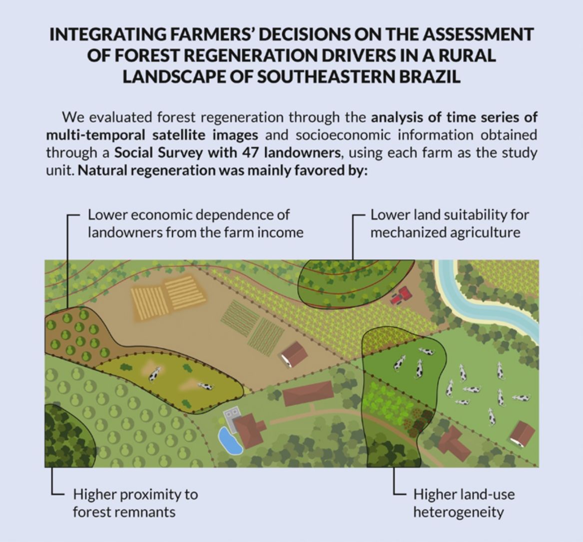
Forest regeneration at large-scales is one of the main paths to achieving the ongoing ambitious restoration commitments. Thus, the identification of the main drivers of this process in agricultural landscapes is critical to understand the drivers determining restoration success. A growing number of studies have explored the biophysical and, less often, the socioeconomic drivers of forest regeneration using remote sensing approaches, but have not directly considered the influence of farmers’ decisions in spatial prediction models of forest regeneration. We explored the influence of biophysical and socioeconomic drivers on forest regeneration in a rural landscape of Southeastern Brazil, where native forest cover increased by 7.7%. We evaluated forest regeneration through the analysis of time series of multi-temporal satellite images and socioeconomic information obtained through a Social Survey with 47 landowners, using each farm as the study unit. Natural forest regeneration was mainly favored by lower land suitability for agriculture and higher proximity (lower distances) to forest remnants, as well by higher numbers of land-uses types in the farm and lower economic dependence of landowners from the farm income. Our results emphasize the importance of considering farmers’ decisions on predictive models of natural forest regeneration, which are critically needed to guide the implementation of large-scale forest restoration initiatives in agricultural landscapes.
Forest regeneration (i.e. natural forest regrowth) is the central promise to achieve forest and landscape restoration commitments and mitigate the global biodiversity and climate crisis (Chazdon et al., 2020). This restoration approach has shown to be more scalable and cost-effective than tree planting (Crouzeilles et al., 2017), yet deciding which areas could be restored through regeneration is still a critical research challenge. It is necessary understand where forest is regenerating in agricultural landscape and what are the drivers of their development and persistence (Brancalion et al., 2016b; Reid et al., 2018). Many recent studies have tried to understand the main drivers of forest regeneration based on remote sensing analyses of land-use change and to associate the regeneration probability to spatial drivers (e.g., Crouzeilles et al., 2020a; Molin et al., 2018; Nanni et al., 2019). In general, these studies have demonstrated that the chances of forest regeneration increase in steeper slopes (>12%), close to forest remnants, inside protected areas, and far from population centers (Borda-Niño et al., 2020).
Overall, forest regeneration in a particular area would be determined by the chances of being abandoned and recolonized by native forest species (Arroyo-Rodríguez et al., 2017). For instance, terrain slope is a key determinant of agriculture mechanization, which is a relevant for land management decisions when rural labor becomes scarce or land-use changes. In contrast, proximity to forest remnants is associated with the likelihood of seed dispersal to abandoned areas. Although some spatial drivers assessed through remote sensing can be useful surrogates of forest regeneration chances, some critical drivers rely on social surveys that have been rarely employed in restoration programs (Wortley et al., 2013). The integration of social survey findings with remote sensing approaches can potentially enhance the forest regeneration model’s accuracy at the landscape scale and approximate them to land management decision-making.
Here, we explored the influence of biophysical (i.e. altitude, slope, topography and distance to rivers and remnant forest patches) and socioeconomic (related to the landowner and to the farm) drivers, including drivers obtained by a survey with local farmers, on forest regeneration in a rural landscape of Southeastern Brazil. We hypothesized that biophysical and socioeconomic drivers are significantly correlated to forest regeneration. We expect that the inclusion of socioeconomic drivers obtained by social surveys positively complement the use of spatial drivers traditionally employed in forest regeneration studies, thus highlighting the importance of social science tools to guide decisions and improve spatial prioritization in restoration programs.
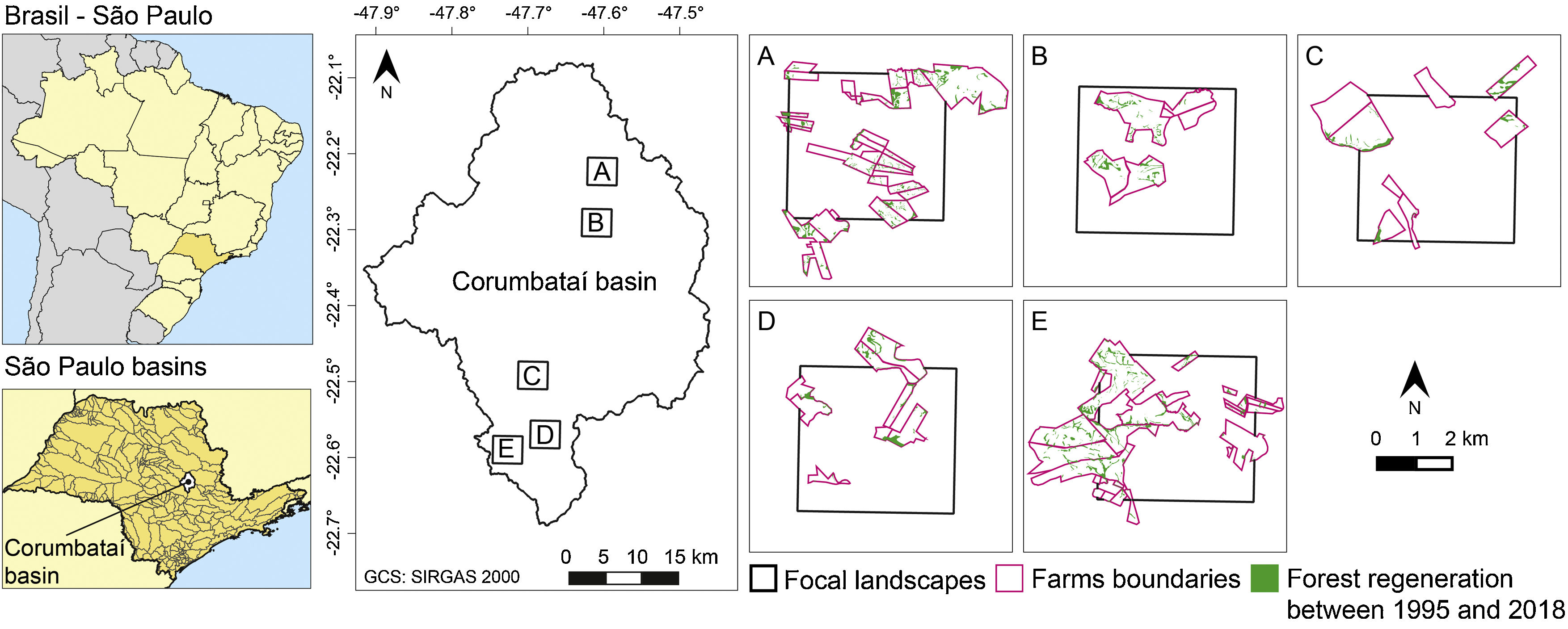
MethodsStudy siteThe study area was the Corumbataí River basin, located in São Paulo State, in Southeast Brazil. The basin encompasses 1700 km2 and ranges in elevation from 470 to 1058 m. It has a mean annual temperature of 22 °C and an annual rainfall of 1390 mm. The topography varies from flat to steep, with a higher percentage of steep slopes in the northwest of the basin (Valente, 2001). Main land-uses are sugarcane fields (44%, mostly on lowlands between 470 to 600 m), extensive pasturelands for dairy and beef cattle (26%, mainly on slopes and highlands between 600 to 1508 m), and native forest (16%). The remaining area is occupied by eucalypt plantations and other crops (Ferraz et al., 2014). Native forest cover increased by 7.7% during the study period (1995–2018). Most of the area where native forest increased were formerly occupied by extensive pastures (54.5%), sugarcane (37.2%), and eucalypt plantations (3.9%). Detailed information on areas with native forest increase and a brief history of the occupation of the territory is presented in Supplementary Material 1.
Data gatheringAn “observational cross-sectional” study design was adopted for data collection and analysis. It involves observation of events that occur naturally without the active intervention of the researcher and can be useful to look for relationships among drivers without a focus on causality (Newing et al., 2010). The biophysical and socioeconomic drivers of forest regeneration were evaluated using a Generalized linear mixed-effects models (GLMM; “Lme4” package from R software, Bates et al., 2015), based on the drivers and procedures described below.
Drivers of forest regenerationWe obtained forest/non-forest thematic maps (scale 1:10,000) for five 36 km2 focal landscapes for the years 1995 and 2018 from visual interpretation of WorldView 1 satellite images (pixel size: 3 × 3 m) and panchromatic aerial photographs (scale 1:25,000). These five focal landscapes were previously selected to representing the landscape diversity of the Corumbataí River basin (Ferraz et al., 2014). Three of these five landscapes were placed at the south of the basin in areas with a predominance of sugarcane fields and, other two in the north of the basin with a predominance of pasturelands (Fig. 1). A more detailed description of the construction of thematic maps and determination of study landscape sizes and their location is available in Ferraz et al. (2014).
We defined the “forest” class as an area above 0.15 ha (minimum mapping unit for the forest/non-forest thematic maps with 1:10,000 scale) and above 75% of canopy closure, determined both by the presence of trees and shrubs and the absence of other predominant land-use classes: sugarcane fields, citrus plantation, eucalyptus plantation, pasturelands, urban areas, exposed soil, water bodies and others. This definition is in line with cartographic representation of forest concept propose by United Nations Food and Agriculture Organization (FAO), also adopted by Brazilian National Forest Information System (SNIF, 2019). We also considered as forest those regenerating from eucalyptus plantations abandoned after harvesting, which resulted in a mixed community of resprouting Eucalyptus spp. and naturally regenerating native trees (see details on the structure and composition of these forests in César et al., 2018). Thematic maps for 1995 and 2018 were combined in ArcGis 10.5 and reclassified to show areas where forest regeneration occurred during the period (i.e., a change from “non-forest” to “forest” class). The resulting map hardly included fallow transitional areas because, in focal landscapes, the time that the land remains without crops did not exceed three years.
Independent biophysical and socioeconomic driversThe selection of biophysical (i.e., features of the natural world) and socioeconomic drivers (i.e., human-created) were based on the conceptual framework presented by Geist and Lambin (2001), and considered variables that have consistently influenced natural regeneration in several tropical regions (Borda-Niño et al., 2020; Chazdon et al., 2020) and, particularly, in the Corumbataí River basin (e.g., Ferraz et al., 2014; Molin et al., 2018, 2017). The biophysical variables were obtained by thematic maps, while the socioeconomic drivers were obtained through a social survey in which farm was chosen as unit of analysis (Table 1, Supplementary Material 2). Biophysical drivers were related to altitude, slope, topography, and distances to permanent rivers and remnant forest patches. Socioeconomic drivers were related to landowner (e.g., education level, age, number of farms owned, total annual income, percentage of total income derived from in-farm agricultural activities) and farm (e.g., size, number of land-use types, main commercial product) characteristics.
Data used to assess the influence of biophysical and socioeconomic drivers on forest regeneration at Corumbataí River basin in São Paulo State, Brazil. Definition of biophysical and socioeconomic drivers are presented in Supplementary Material 2.
| Biophysical variables of regenerating forests | Data |
|---|---|
| Altitude (m)a | Level curves (IGC-SP, 1970) |
| Slope (degrees)a | |
| Topographic Position Indexa | |
| Euclidean distance to the closest permanent river (m)a | Rivers (Departamento de Águas e Energia Elétrica-DAEE, 1:10.000) |
| Euclidean distance to the closest forest remnant mapped in 1995 (m)a | Forest/non-forest thematic maps from 1995 |
| Socioeconomic variables | |
| Attributes related to the landowner | Social survey |
| - Place of living (in the farm/out of the farm) | |
| - Level of education | |
| - Age | |
| - Farm agricultural activities (yes/no) | |
| - Use of family labor in agricultural activities (yes/no) | |
| - Number of farms owned | |
| - Total annual income (minimum wages) | |
| - Percentage of total income derived from in-farm agricultural activities | |
| - Number of sources of income other than agricultural farm activities | |
| Attributes related to the farm | |
| - Size (ha) | |
| - Time of land ownership by the interviewed farmer (years) | |
| - Number of residents | |
| - Cattle stocking rate (animals ha−1) | |
| - Number of land use types | |
| - Main commercial agricultural product | |
| - Changes in agricultural activities, the main commercial product (yes/not) | |
| - Euclidean distance to the closest unpaved or paved road (m)a | Roads (DAEE, 1:50.000) |
| - Euclidean distance to the closest population center (m)a | Municipalities (IBGE, 2010) |
The social survey involved a probabilistic sampling and the collection of socioeconomic data (Newing et al., 2010). We considered a quadrant in each focal landscape to define the independent socioeconomic variables of the model, resulting in five 16 km2 quadrants. We found 359 rural properties inside the five quadrants or in contact with their boundaries which were obtained from digital maps available on the online platform of the Rural Environmental Registry system (CAR). The rural properties ranged from 0.001 to 13.85 km2 in size and covered a total area of 113.14 km2. From this sampling frame a stratified random sampling based on property size was performed using the Natural Breaks method in ArcGis 10.5. This method is based on natural grouping inherent in the data, where breaks group similar values, maximizing the differences between classes (Smith et al., 2007). The sample size was defined for each stratum considering the minimum number required for a 95% level of certainty (Saunders et al., 2009). As a result of this procedure, we defined a sample of 252 rural properties (total area of 110.90 km2), of which 96 properties (38%) belonging to 65 landowners were successfully sampled. Among them, 47 landowners of 70 rural properties (total area of 26.95 km2), were identified as eligible for this study for owning the land from, at least, 13 years, a period that is more than half of the study period (1995–2018).
The social survey consisted in field structured interviews with landowners, conducted from August 2017 to March 2018, in which specific quantitative questions on land-use and general socio-demographic characteristics were made (Supplementary Material 3). We applied one questionnaire per property and interviewed the landowner. For properties with more than one owner, we interviewed the one managing the land. We spatialized the socioeconomic drivers and combined them with the biophysical drivers for further analyses (Table 1). Detailed information on the socioeconomic attributes of landowners and rural properties are presented in Supplementary Material 4.
Model development and validationThe Moran index on the slope map was calculated to select uncorrelated sampling points of the dependent and independent variables in the geographic space. Moran index allows estimating from which distance a point can be considered independent of the other. The magnitude of each variable at each sample point (n = 1750 points separated by 150 m) was determined by the data collection from biophysical and socioeconomic maps. The extracted data constitute the dependent and independent variables of the linear mixed model. Both the calculation of the Moran index and the aggregation of maps for data collection at the sampling point were performed using the “raster” package from R software.
In the global Generalized linear mixed-effects model (GLMM; Harrison et al., 2018), only independent variables (i.e. drivers) with Pearson correlation coefficients <0.5 were retained. For each pair with high correlation, we retained the most relevant variable according to the literature to explain forest regeneration, and discarded the other variables (Supplementary Material 5; Table 2). The predictive not correlated variables were fit as a fixed factor in GLMM, while the Id of the landowner, Id of the farm, and Id of the quadrant inside the focal landscape were fit as random factors to explicitly model the non-independence between observational units (Harrison et al., 2018). In this study, the non-independence was a consequence of the chance to select more than one sampling point per farm, or of the landowner owning more than one sampled farm. In both situations, the sampling point will have the same values of socioeconomic variables related to the landowner. An automated model selection (“MuMIn” package from R software) was performed from the global model to generate a table of models with combinations (subsets) of fixed factors in the global model. The total number of models created was 8192. We select the conditional average model from all models with delta second-order Akaike Information Criterion (ΔAICc) <2. The ΔAICc value for the null model was 316.7.
Independent variables (i.e. drivers) with Pearson correlation coefficients <0.5 used in the global Generalized linear mixed-effects models (GLMM) to explore the biophysical and socioeconomic drivers of forest regeneration at Corumbataí River basin in São Paulo State, Brazil.
| Biophysical variables |
| Altitude (m) |
| Slope (degrees) |
| Topographic Position Index |
| Euclidean distance to the closest permanent river (m) |
| Euclidean distance to the closest forest remnant mapped in 1995 (m) |
| Socioeconomic variables |
| Attributes related to the landowner |
| - Percentage of total income derived from in-farm agricultural activities |
| - Number of sources of income other than agricultural farm activities |
| Attributes related to farm |
| - Size (ha) |
| - Time of land ownership by the interviewed farmer (years) |
| - Number of residents |
| - Number of land use types |
| - Main commercial agricultural product |
| - Euclidean distance to the closest unpaved or paved road (m) |
The forest regeneration occurrence significantly increased at lower Euclidean distance from forest remnants and rivers, in steeper slopes (>10%), and at a lower altitude (between 470 to 600 m). Forest regeneration was most likely to occur in farms with commercial agricultural production other than permanent crops of sugarcane and beef and dairy cattle, in farms with higher number of land-use types, with few residents, and belonging to landowners with low economic reliance from agricultural activities (Table 3). GLMM results are detailed in Supplemental Material 6.
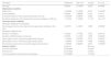
Conditional average model (n = 1750 sample points) to explore the biophysical and socioeconomic drivers of forest regeneration at Corumbataí River basin in São Paulo State, Brazil. Two asterisk indicates a P-value <0.05 and one asterisk a P-value <0.1.
| Variables | Coefficient | Std. error | Z value | Pr (>|z|) |
|---|---|---|---|---|
| Intercept | 0.33002 | 0.73978 | 0.446 | 0.65558 |
| Biophysical variables | ||||
| Altitude (m) | −0.36398 | 0.15836 | 2.297 | 0.02162** |
| Slope (degrees) | 0.33642 | 0.06698 | 5.019 | 5 e-07** |
| Euclidean distance to the closest permanent river (m) | −0.30768 | 0.09955 | 3.089 | 0.00201** |
| Euclidean distance to the closest forest remnant mapped in 1995 (m) | −1.18199 | 0.10569 | 11.176 | <2 e-16** |
| Socioeconomic variables | ||||
| Attributes related to the landowner | ||||
| Percentage of total income derived from agricultural activities in the farm | −0.25701 | 0.13531 | 1.898 | 0.05769* |
| Attributes related to farm | ||||
| Number of residents | −0.32421 | 0.17302 | 1.873 | 0.06112* |
| Number of different types of land use | 0.33678 | 0.17387 | 1.936 | 0.05290* |
| Dairy cattle as main commercial agricultural product | −1.44929 | 0.63708 | 2.273 | 0.02301** |
| Beef cattle as main commercial agricultural product | −1.08660 | 0.57520 | 1.888 | 0.05905* |
| Permanent crops as main commercial agricultural product | −1.45805 | 0.56324 | 2.587 | 0.00968** |
| Random effects | Variance | Std. Dev | ||
| Id of the landowner | 0.0009246 | 0.03041 | ||
| Id of the farm | 0.6197039 | 0.78721 | ||
| Id of the quadrant inside the focal landscape | 0.0153899 | 0.12406 | ||
Forest regeneration is determined by biophysical and socioeconomic drivers occurring and interacting at multiple temporal and spatial scales (Arroyo-Rodríguez et al., 2017; Chazdon et al., 2020; Crouzeilles et al., 2020b). But land-use changes are consequence of decisions made by people in the landscape, and these decisions are determined not only by socioeconomic or biophysical factors, but also by policies. At the Corumbataí River basin forest regeneration between 1995 and 2018 is correlated with a combination of biophysical drivers and farmers decisions on land abandonment (Molin et al., 2018). The regeneration of native forests was more frequent on steeper slopes (>10%) previously used for extensive cattle ranching, and dependent on the economic context of the study period (Ferraz et al., 2014; Molin et al., 2017). In 1991, after deregulation of the dairy sector by the Brazilian government, high levels of price instability affected mainly small ranchers and resulted in a progressive abandonment of less productive pasturelands (Siqueira et al., 2010). The influence of slope in forest regeneration is even more pronounced in sugarcane production areas, which rely on mechanized agricultural activities that are compromised in slopes >12% where the machines are not manageable (Ferraz et al., 2014; Molin et al., 2017).
A second group of biophysical drivers related to forest regeneration was associated with regeneration processes and environmental laws, as forest regeneration tended to occur closer to older forest patches and permanent rivers. Seed dispersal is favored at higher proximity (lower distances) from forest remnants, which act as a source of both seeds and animal dispersers (Chazdon et al., 2020). The direct correlation with proximity to permanent rivers on forest regeneration was likely related to the compliance with Brazil’s Forest Code, which prohibits agricultural activities in riparian buffers and mandates their restoration (Brancalion et al., 2016a). Complementary, forest regeneration can be more likely along streams due to lower dispersal limitation, as small forest patches and isolated trees are common features of riparian areas and animals heavily use them as ecological corridors (Şekercioğlu et al., 2015).
Regarding socioeconomic drivers, forest regeneration was higher in farms where landowners have lower economic dependence from the farm’s income. However, this result can change over time since fluctuating market demands affect the revenues obtained by agricultural commodities, which in turn can encourage deforestation or natural regeneration by land abandonment (Busch and Ferretti-Gallon, 2017). The rate of land-use change is commonly associated with demands for primary commodities and is often modeled using an economic framework (Jadin et al., 2016). Nevertheless, our results suggest that the economic dependence from farming is strongly related to the economic dependence from the land area, and not only the per capita income or socioeconomic status (e.g., Newman et al., 2014).
The high economic reliance of some landowners from farming highlights the need to implement new production models that promote the more efficient use of natural resources and reduce pressure on regenerating forests. Nowadays there are alternative farming systems that can reconcile production and conservation, such as agroforestry and silvopastoral systems (Calle, 2020; Ceccon, 2013), which have been recently framed under the “regenerative agriculture” umbrella. Complementary, the regeneration of forests on lands with low agricultural potential may sequester enough carbon quantities to be subsidized by Payments for Ecosystem Services and then to ensure their longer-term permanence (Chazdon et al., 2016b; Rudel, 2015), although current carbon pricing is often insufficient to overcome land opportunity costs in the study region (Brancalion et al., 2021). Forest regeneration appears to be more probable in properties with fewer residents, where labor availability for managing less productive lands is scarcer and favors the adoption of mechanized cropping systems, which in turn may result in the abandonment of steeper areas (Rudel, 2015). The higher forest regeneration in farms with diverse land-use types was probably related to the establishment of a more favorable landscape matrix for seed dispersers movement, which may have their flows favored in more diverse mosaics of eucalypt plantations and agro-pastoral land uses (Borda-Niño et al., 2017). In fact, we report secondary forests regenerating following the abandonment of eucalypt plantations after their harvesting, which can be the object of assisted natural regeneration strategies and enrichment plantings with native species, contributing to both carbon stocking and biodiversity conservation (César et al., 2018). Other explanation is the more selective use of the land, which is also related with the permanence of the landowners in rural areas. Over time, the landowner gets better acquainted with their lands and their forests, and promote a more selective use of the natural resources of the farm areas to comply with environmental rules and of agro-pastoral systems to maximize production (Mofya-Mukuka and Hichaambwa, 2018).
Part of the dynamism of forest cover that characterized the studied landscape and resulted in an increase of native forest cover may be a temporal situation. Marginality is relative to the opportunity cost of different land uses and legal constraints, all of which may change independently of biophysical conditions (Sloan et al., 2016). For instance, if new machinery to cultivate sugarcane in sloppy areas is developed, or if the Native Vegetation Protection Law (i.e. the so called Brazilian Forest Code) is reformed again (as it was in 2012) to reduce the need for protection and restoration of native forests, a large portion of second-growth forests can be reconverted to agro-pastoral land uses. The importance of these forests for agriculture needs to reconsidered based on their origins, dynamic properties and landscape settings to better support their protection and restoration, and leverage their contributions to achieve global restoration targets (Chazdon et al., 2016a).
Recognize that the increase in native forest cover observed in the study area may not be necessarily accompanied by substantial environmental benefits results crucial. It is particularly important as the regeneration of young secondary forests, which take decades to accumulate carbon stocks and native species in marginal agricultural lands, can co-occur with the clearance and degradation of mature forests in flatter areas prone to mechanized agriculture (Brancalion and Holl, 2020). Detailed monitoring of forest structure and diversity is needed (see César et al., 2018 for forest biodiversity and carbon stocking information in the study region). It can benefit from novel remote sensing approaches and drone-lidar systems (Csillik et al., 2019) to be performed at the landscape scale.
Our local study highlights the importance of integrating social science tools to gather socioeconomic, non-spatial information on relevant drivers of forest regeneration, thus emphasizing the importance of considering farmers’ decision on restoration planning. As the Corumbataí River basin hosts a diverse gradient of socioeconomic and biophysical conditions, our findings can be considered in other geographical contexts.
Declaration of interestsThe authors declare that they have no known competing financial interests or personal relationships that could have appeared to influence the work reported in this paper.
We thank all the Corumbatí River basin landowners and his families for sharing with us their knowledge, agricultural engineers of CATI (Coordenadoria de Assistência Técnica Integral) of Corumbataí, Ipeúna and Charqueada municipalities for the valuable assistance during fieldwork, ESALQ students who help on fieldwork, Vanessa Erler Sontag for the graphic work, Aline Fransozi for the assistance with GIS and Francisco Mora Ardila for statistical support. M. B. N. thanks the Coordination for the Improvement of Higher Education Personnel of Brazil (CAPES, grant 88882.195680/2018-01). P. M. is supported by the São Paulo Research Foundation (FAPESP, grant 2016/00052-9) and Fondecyt (Project 11191021). E. C. thanks the Program to Support Research Projects and Technological Innovation, National Autonomous University of Mexico (PAPIIT-UNAM, grant IN300119) for financial support.
The following is Supplementary data to this article:


- Home
- All contents
- Publish your article
- About the journal
- Metrics
- Download PDF
- Bibliography
- Additional material