Wetlands play an important role for water, carbon storage and biodiversity in the seasonally dry and hot environments of tropical savannas. Peatlands, which are permanent wetlands, are important as the carbon-richest parts of wetland ecosystems with a strong ability to store carbon, retain water and regulate its flow. With this first review on peatlands in the Cerrado we synthesize existing knowledge and gaps on their distribution and types in the biome including, vegetation, soil properties, carbon stocks and hydrogeomorphology. Peatlands are embedded in wetland complexes in valleys, groundwater-fed oligo- to mesotrophic, with wet grass- and shrubland, Vereda or riparian swamp forest vegetation. Average peat depth is 1.4 meters and soil carbon stocks in the first meter can be 9 times higher than in mineral soils under Cerrado dryland vegetation, reaching about 1000 t carbon per hectare. Total soil carbon stock estimates (3.19 Gt C) in peatlands equal 13.3% of the total soil carbon in the Cerrado in only 0.7% of its total area, although large uncertainties exist. Actual peatland occurrence appears to be more abundant than current soil and peat maps suggest. The high rate of transformation of the native vegetation into industrial agriculture and wood plantations, which affects large parts of the Cerrado, is a major cause for the degradation and the loss of peatlands and other wetlands. However, the extent of peatland degradation and resulting carbon losses remain unfathomed. We identified research needs such as better mapping and monitoring, and recommend including peatlands into wetland classification systems in Brazil.

In the frame of the climate crisis and the urgent need to identify, preserve, and strengthen natural carbon sinks for climate change adaptation and mitigation, there has been growing interest in wetlands. However, despite their significant role in climate regulation, biodiversity, and hydrological buffering, wetlands are globally the most at-risk and degraded ecosystems (Fluet-Chouinard et al., 2023). In this context, peatlands, which are permanent wetlands, when in a natural state (Box A), are especially important as they represent the carbon-densest terrestrial ecosystems. They store approximately 600 Gt, or 25% of the global soil organic carbon, on only three percent of the global land surface. From a carbon perspective, 15 cm of peat contain as much carbon as a high-carbon tropical forest (Barthelmes et al., 2015). When drained, peatlands become important sources of greenhouse gas (GHG) emissions, contributing between 2.6 and 3.8% to global annual anthropogenic emissions (Humpenöder et al., 2020; UNEP, 2022).
Tropical peatlands cover 90−170 Mha, or 23–30% of the total global peatland area and store 152–288 Gt of carbon (Humpenöder et al., 2020; Ribeiro et al., 2021). Globally important tropical peat regions are the Congo basin, the Peruvian Amazon, and Southeast Asia (UNEP, 2022). However, peatlands can also be found in tropical savanna regions, such as the Angolan highlands, the Nile basin, the Orinoco savanna in Venezuela as well as the Roraima savannas in Venezuela and Brazil. There, peatlands generally are part of wetland complexes in valleys and depressions, and are often situated in headwater regions, where they function as permanent water reservoirs and regulators, as well as biodiversity corridors in seasonally dry environments (UNEP, 2022). Human activities often negatively impact these peatlands (Elshehawi et al., 2019; UNEP, 2022).
Knowledge on the distribution, development, hydrology and degradation status of tropical savanna peatlands is limited (UNEP, 2022). This is especially true for the Cerrado in Brazil, the largest neotropical savanna region, where peatlands have not yet been assessed systematically and in detail, except for the Espinhaço Meridional mountain range (Silva et al., 2022a; UNEP, 2022). Based on preliminary estimates, there are 3,112 km2 of peat soils in the Cerrado and an additional 6,361 km2 of associated soil types (Fig. 1) (Global Peatland Database, 2022). The combined area represents less than one percent of the Brazilian Cerrado. Peat has been confirmed sporadically in the wettest parts of stream valleys, where it is often associated with a vegetation type called Vereda, which is a type of swamp savanna often with characteristic Mauritia flexuosa palms (e.g., Cassino et al., 2018; Horák-Terra et al., 2022a; Wantzen et al., 2012).
High land use pressure and climate change critically endanger the preservation of wetland ecosystems including peatlands in the Cerrado. 50% of the total natural vegetation has already been converted, mainly for agriculture (Alencar et al., 2020), resulting in lower ground water levels, drier wetlands and reduced river runoffs (Rápalo et al., 2021; Silva et al., 2022b). To understand the consequences for the Cerrado peatlands including carbon losses, peatland types and extent, as well as their role in carbon storage and in the water cycle need to be assessed (FAO, 2020).
This literature review presents current knowledge on vegetation, carbon stocks, soil properties, and hydro-geomorphological landscape settings of peatlands in the Brazilian Cerrado. The threats posed by land use, the legal protection status of peatlands and wetlands in general, and finally the limitations and shortcomings of the current peatland knowledge will be summarized.
Box A Definitions “Peat, peatland, wetland”
Peat (Portuguese: turfa) is partially decomposed organic material that sedentarily accumulated due to permanent water saturation of the soil. Peatlands (pt: turfeiras) are areas with an accumulated peat layer at the surface. Depending on the definition, peat has at least 12–18% organic carbon by weight in the uppermost 20–50 cm of the soil (UNEP, 2022). Peat soils, also referenced as Histosols, are part of organic soil classes. Since organic soils include soils with organic carbon content lower than 12–18%, not all organic soils are peats. In Brazil, peat soils fall under the organic soil sub-classes “thiomorfic” (pt: tiomórfico) or “humic” (pt: háplico), but they can be found in other soil classes, if the organic surface horizon is shallower than 40 cm (Santos et al. 2018). Wetlands are areas which are temporarily or permanently inundated or water-saturated with vegetation adapted to saturated soil conditions. All natural peatlands are permanent wetlands (Bonn et al., 2016).
For our literature review, we searched for peer-reviewed articles, conference papers, and PhD theses in English and Portuguese using Web of Science, Google Scholar and Scielo, and the references in identified studies. We considered studies on the Cerrado if one or more of the terms “peat”, “peatland”, “histosol” or their Portuguese equivalents “turfa”, “turfeira” or “organossolo” were mentioned, or if soil organic carbon data showed at least 12% soil organic carbon or 35% soil organic matter content by weight. We also included studies in which the topsoil was classified as organic or Histosol without further information on thickness of the organic layer. We excluded studies with deeper measurements that showed an organic soil layer of less than 20 cm. Following the above-mentioned criteria, we also included locations from the Continuous Pedology Database of Brazil of the Environmental Data and Information Bank (IBGE, 2021), the Information System of Brazilian Soils (ISBS) (Embrapa Solos, 2014) and the peat location collection of Valladares et al. (2008), which is partly based on the ISBS. (i) Coordinates of peat occurrence, (ii) thickness of the peat layer (length of cored peat profile), (iii) soil carbon content and stocks (iv) additional soil properties and (v) vegetation type information was extracted. For carbon content and stocks, we calculated the weighted average per peat profile and subsequently the average over all profiles. We did not include mountain peatlands from the Espinhaço Meridional Mountain range with an area of 140 km², because of its distinct geographic extent and its geological, biogeographical, and climatic differences to the rest of the Cerrado. In addition, peatland information for this region has already been summarized by Silva et al. (2022a). To update peat areas for the Cerrado, we overlayed the two classes of the Global Peatland Map2.0 (GPM) peat-dominated and peat-in-patches in 1 × 1 km resolution (Global Peatland Database, 2022) with the organic soils in the first component (as “peat-dominant”) and organic soils as associations or inclusions with other soil types (as “peat-in-patches”) of the Brazilian soil map (IBGE, 2021). The GPM is a compilation of various published dataset and includes information of the Brazilian soil map that is primarily based on soil surveys. In overlapping peat areas of both maps, the original outline of the Brazilian soil map with finer scale was used for better accuracy.
Cerrado region – geology, geography, climate, wetlandsThe Cerrado is the largest and most biodiverse neotropical savanna region. It covers an area of more than 2 million km² mainly of the elevated central parts of Brazil, where flat or gently undulating terrain and plateaus are dominant (Klink and Machado, 2005). The dominant climate is tropical seasonal (Aw) according to Köppen, with a dry season from May to October and a wet season from November to April. At higher altitudes, dry winter humid subtropical climate (Cwa) occurs. The annual precipitation ranges from 600 to 2000 mm (Sano et al., 2019), and the mean annual temperatures range from 18 to 27 °C (Silva et al., 2008a). The vast majority of the region is covered by old, leached, and deeply drained facies, characterized by acidic and nutrient-poor soils with low water holding capacity such as Ferrasols (48,7%), Arenosols (14,5%) and Acrisols (13,7%) (Schaefer, 2023).
Wetlands cover up to 15% of the Cerrado and play a major role in Brazil’s water cycle (Junk et al., 2022). The region is characterized by a dense stream network that drains in valleys from the headwaters at plateaus towards lowland regions, where it sustains some of the largest South American rivers (Wantzen et al., 2006). In the valleys, seasonal and permanent wetlands transition to well-drained areas, creating a mosaic of peat and organic soils and mineral soil types, like Arenosols, Cambisols, Plinthosols and Gleysols (Junk et al., 2022; Nunes da Cunha et al., 2024). The type of wetland vegetation mainly depends on wetness, soil properties and nutrients (Durigan et al., 2022; Bijos et al., 2023) (Suppl. A).
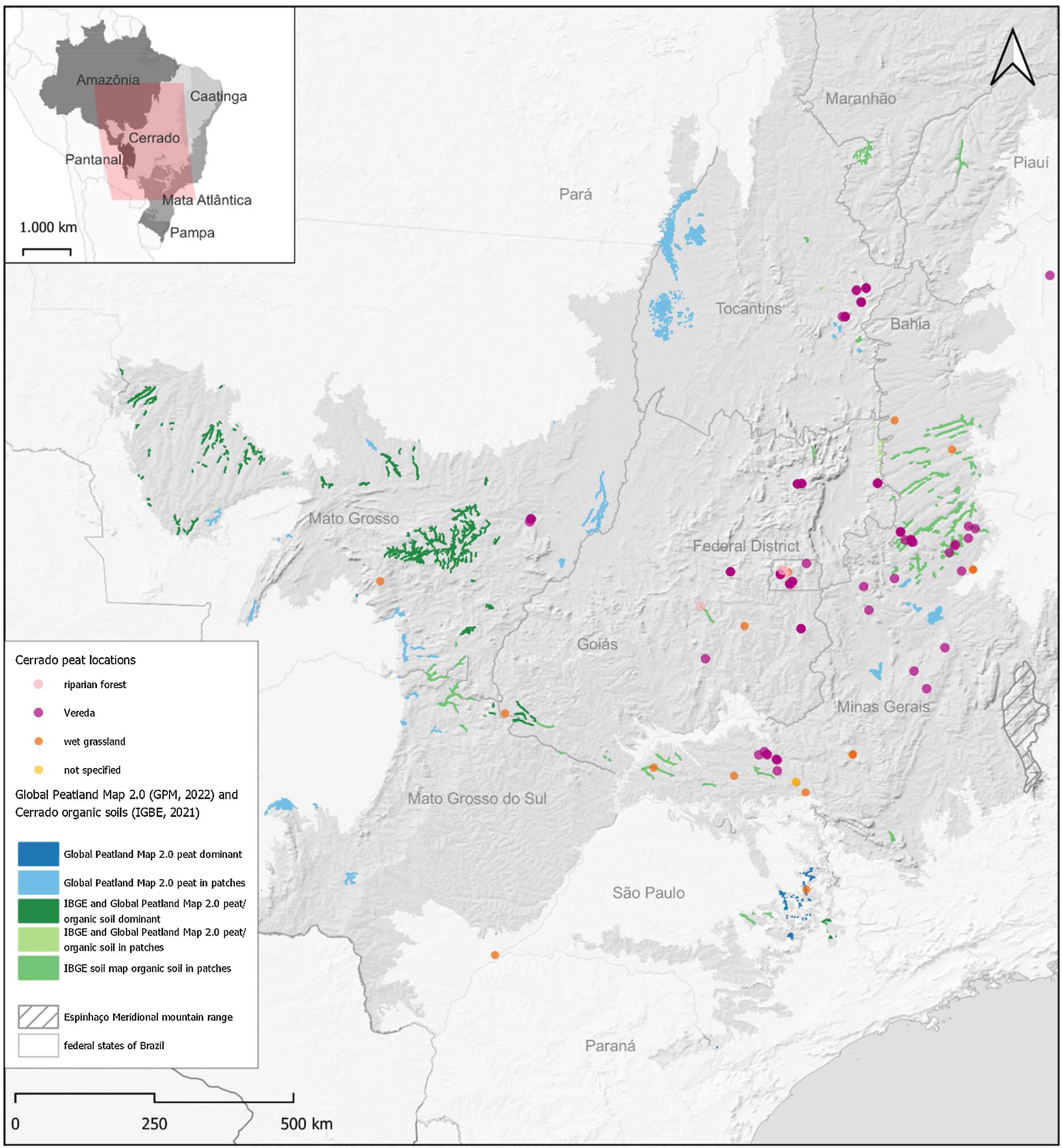
ResultsPeatland distributionAccording to the GPM (GPD, 2022) and the Brazilian soil map (IBGE, 2021), peat and organic soils can be found in valleys across various regions of the Brazilian Cerrado, including southwestern Bahia, western Tocantins, northern Minas Gerais, Mato Grosso, and smaller patches in Mato Grosso do Sul, Maranhão, and Piauí (Fig. 1). The combined area of peat and organic soils from the two maps covers 13,386 km2, with 2,951 km2 overlapping (Suppl. D). The peat location collection from literature reveals three main clusters with reported peat occurrence: (i) Federal District, (ii) Northern Minas Gerais, and (iii) western Minas Gerais/Goiás, locally known as Triângulo Mineiro. The clustering of peat locations in the three regions may be biased by the vicinity to universities with a research focus and history on wetlands. Singular peat occurrences were also reported in valleys in western Bahia, the Jalapão region/Tocantins, Mato Grosso, and Maranhão (Fig. 1, Suppl. B). All peat locations, except for one, were located in valleys. The exception in southern Minas Gerais borders a lake in a depression. Only 22 out of 171 peat locations from literature matched with peat areas of either of the two maps, indicating an underrepresention of the Cerrado peat area in maps with additional peat areas remaining unmapped. The lack of ground validation points from organic soils in the two Brazilian soil databases from IGBE and Embrapa Solos, the small size and patchiness of peat areas and difficult identification due to wetland vegetation that grows on both organic and mineral soils are some reasons for the omission of peat areas.
, extent of peat according to the Global Peatland Map2.0 (GPD, 2022) and organic soils from the pedology compartment of the environmental information database (IBGE, 2021), overview map: Brazilian biomes and main map extent (reddish).")
Cerrado peat locations with vegetation type (this study), extent of peat according to the Global Peatland Map2.0 (GPD, 2022) and organic soils from the pedology compartment of the environmental information database (IBGE, 2021), overview map: Brazilian biomes and main map extent (reddish).
The literature review confirmed three vegetation formations, wet grass- and shrubland, Veredas and riparian swamp forest, that occur with peat, enabled by permanently wet soil conditions. However, these formations also occur where there are seasonal variations in wetness with hydromorphic mineral soils (Durigan et al., 2022; Nunes da Cunha et al., 2024) (Suppl. B). Vereda is a swamp savanna complex, composed of three zones along a wetness gradient (Eiten, 1994). The outermost zone is a moist grassland covering the periodically dry upper part of the wetland. Downslope, the moist grassland transitions into a wet grassland or wet shrubland (pt: Campo limpo úmido/ Campo sujo úmido) in the middle zone, which is permanently to seasonally wet. Towards the bottom and along the wettest parts of the valleys, the palm Mauritia flexuosa L.f. typically occurs in patches or in lines forming a palm swamp savanna (Ramos et al., 2006; Nogueira et al., 2022; Bijos et al., 2023). This palm swamp savanna often occurs in a mosaic with or alongside riparian (swamp) forest (pt: Mata de Brejo/Galeria) along the stream valleys. The riparian forests in the Cerrado are highly diverse and have species compositions differing between poorly-drained, swampy and peaty areas; and better-drained mineral soils, such as alluvial levees (Silva et al., 2008b; Skorupa et al., 2013; Chiminazzo et al., 2021). The Veredas/ swamp savannas with M. flexuosa palms also occur outside the Cerrado in valleys of the semi-arid Caatinga and in the Roraima savanna region in northern Amazonia, where peat has been confirmed, too (Rull et al., 2016). Other wetland vegetation types in the Cerrado that may have peat soils due to their permanent wetness, but still require confirmation, are M. flexuosa palm groves (pt: Buritizal), Campos de Murundus and temporarily flooded forests (pt: Ipuca) (Durigan et al., 2022) (Suppl. A).
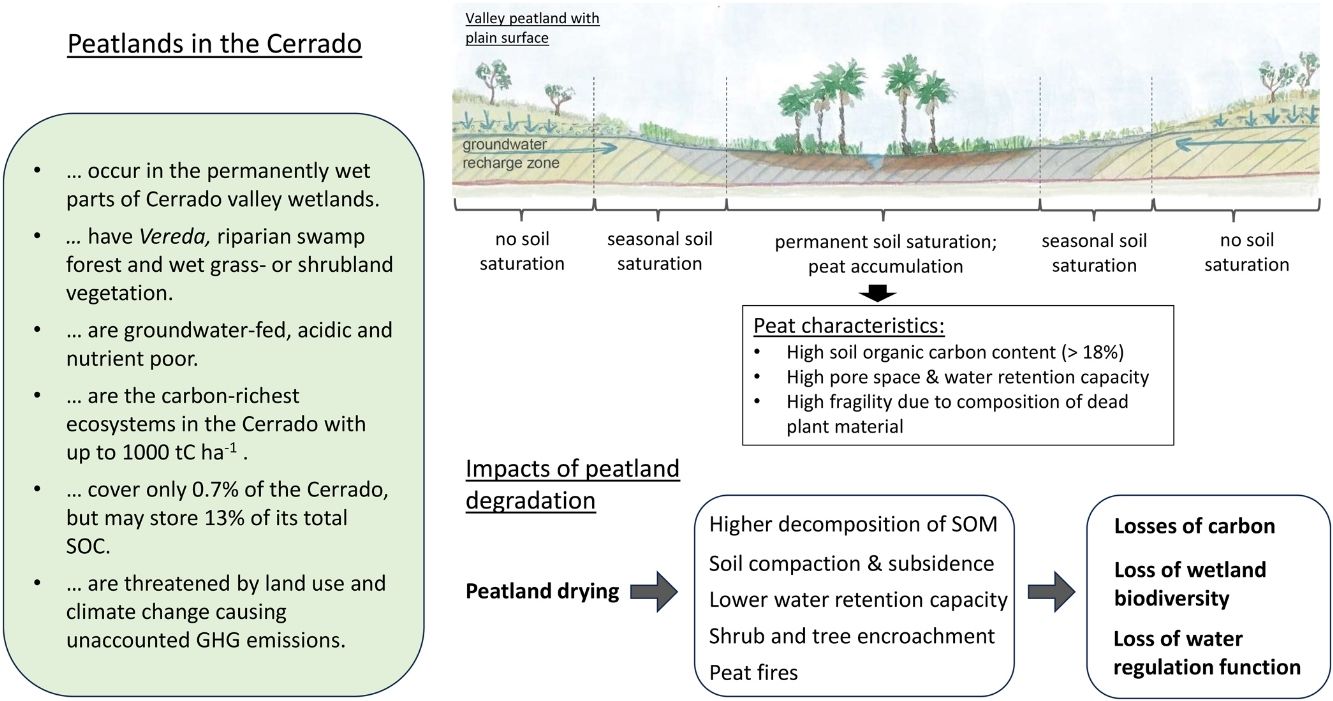
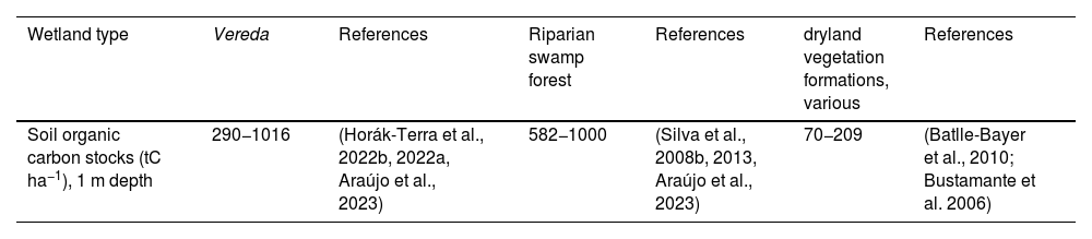
Carbon in peat soilsSoil carbon concentrations and the depth of the organic or peat layer increase from the seasonally wet areas at the wetland edges towards the flat, permanently wet central parts (Ramos et al., 2006; Sousa et al., 2015; Soares et al., 2021). Weighted mean organic carbon concentration was 18.5% (SD = 5.7, n = 144) by weight with a maximum of 49%. The low weighted mean bulk density (BD) values of 0.23 g cm−3 (SD = 0.13, n = 8) (Suppl. C) are related to the high organic matter content and relatively high soil pore spaces typical for peat and organic soil (Ruehlmann and Körschens, 2009). Average depth of the peat layer at locations where the mineral subsoil was reached was 142 cm (SD = 86.6 cm, n = 20) with a maximum peat depth of 329 cm (Suppl. B). In Veredas, soil carbon stocks of the upper meter ranged from 290 to 1016 tC ha-1. In riparian forest, the range was 582−1000 tC ha−1. Soil carbon stock information for wet grassland was not available. The overall average of 615 tC ha-1 (SD = 244 tC ha−1) is 3 to nearly 9 times higher than averages reported for soils under Cerrado dryland vegetation (Table 1). Veredas and Riparian swamp forests with peat soils have the highest carbon stocks in the Cerrado, based on the datasets analysed in this study (Table 1). Considering the low data-density and high bias between studies, we suspect the total carbon stocks per hectare to be even higher, as corroborated in studies from other tropical savannas (e.g., Elshehawi et al., 2019). The low number of BD data for peat soil is an important limitation for more comprehensive carbon stock estimations. Total carbon stocks in peatlands in the Cerrado - based on our average values of soil C in peatlands and total peat area - are 3.19 Gt C, or 13.3% of the total 24 Gt soil carbon stored in the Cerrado (Bustamante et al., 2006) on only 0.7% of its area. The average peat depth reported here is greater than one meter, a depth typically covered by SOC assessments, also indicating even higher carbon stocks by area in Cerrado peatlands.
Organic carbon stocks of wetland types with peat compared to typical dryland in Cerrado (Suppl. C).
| Wetland type | Vereda | References | Riparian swamp forest | References | dryland vegetation formations, various | References |
|---|---|---|---|---|---|---|
| Soil organic carbon stocks (tC ha−1), 1 m depth | 290−1016 | (Horák-Terra et al., 2022b, 2022a, Araújo et al., 2023) | 582−1000 | (Silva et al., 2008b, 2013, Araújo et al., 2023) | 70−209 | (Batlle-Bayer et al., 2010; Bustamante et al. 2006) |
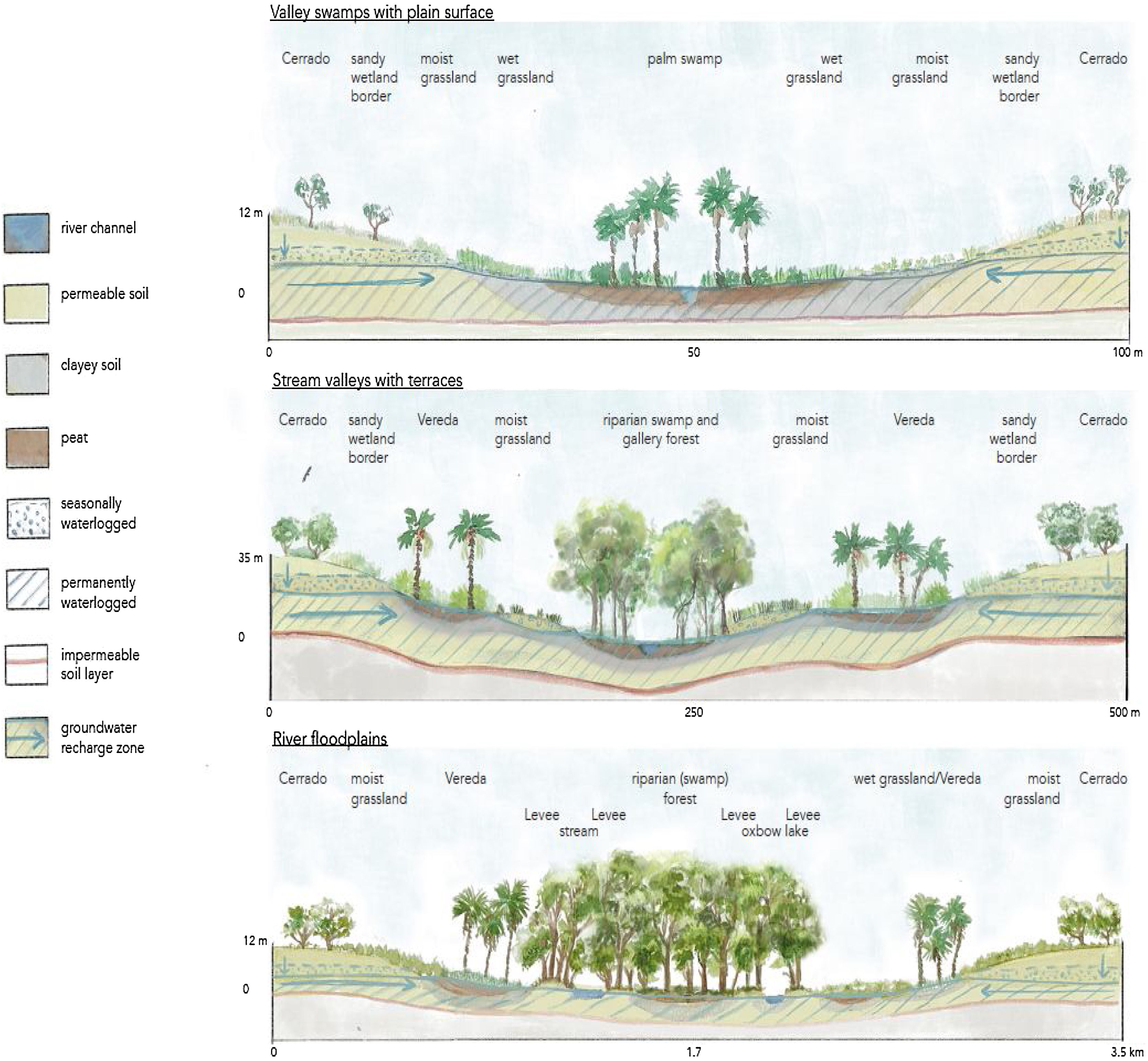
There are several geomorphologically distinct valley types with peatlands in the Cerrado (Nunes da Cunha et al., 2024), representing different stages of landscape development (Moreira and Perez Filho, 2020) (Fig. 2, Box B). At stream sources and low-order streams, peatlands occur in the central parts of flat, undulating and slightly sloping valleys that represent the youngest stage of valley development. These parts are commonly covered by Veredas or wet grasslands. They turn into a riparian (swamp) forest further downstream from the source, where the valleys become wider with peatlands (and Veredas) also occurring at floodplains and terraces (Wantzen et al., 2006). In areas with permanent groundwater seepage, peat can accumulate on the valley slopes.

Soil, vegetation, and hydrological characteristic in cross-sections of valley forms with peat, adapted from Nunes da Cunha et al., 2024; vegetation not to scale. See Box B for description.
Peatlands and other wetlands in the Cerrado are fed by groundwater flows. Rainwater infiltrates the porous soils (i.e., Ferrasols and Arenosols) of the catchments and recharges the groundwater, which moves towards the valleys through permeable soil layers (aquifers) overlying impermeable layers (aquicludes/aquitards) (Moreira and Perez Filho, 2020; Woessner, 2023) (Fig. 2). Alternatively, peatlands can be fed by groundwater from deeper aquifers that are recharged at larger distance and that surface, for example because of faults or preferential flow paths. The hydrological buffering capacity of aquifers ensures a steady baseflow towards valley wetlands where permanently wet conditions with high water tables are maintained also during the dry season (Vasconcelos, 2017).
The quality of the water and peat in the groundwater-fed peatlands of the Cerrado is influenced by the soils of the surrounding catchment. Typically, these are old, leached, nutrient-poor and acidic soils (Schaefer, 2023) characterized by low pH, low nutrient availability and relatively high Al3+ concentrations (Suppl. C). Local variations may occur due to variations in soil or land use practices in the catchment area.
BOX B Valley types with confirmed peat occurrence (Fig. 2) adapted from Nunes da Cunha et al. (in press)
Valley swamps with plain surface
The wettest, permanently water-logged part with peat presence occurs in the lowest section of the shallow, gently sloping valleys. The valleys are between one and six meter deep and 30-150 m wide. Wet grassland, Veredas or riparian swamp forest formations can occur. Groundwater sources at the sides and flows towards the valley bottom, where there is a rivulet in the central part. In some cases organic-rich or peaty soils stretch up the slope with decreasing thickness and organic content (Ramos et al. 2006). These valley types are typically found at the sources and upper parts of the headwater streams of lowest orders, also representing the youngest stage of valley development.
Stream valleys with terraces:
Valleys with plain, wet terraces on the sides, where groundwater discharges, leading to the accumulation of organic or peat soil at terraces under wet grassland or Veredas. The wet terraces are a few meters higher than the valley bottom, which is usually occupied by gallery forest, and occasionally separated by mineral mounts with dryland Cerrado vegetation.
River floodplains with peat accumulation
This type is typical for floodplains or backswamps, which form in wider valleys of advanced geomorphological development and middle-order rivers. A mosaic of soil types forms due to river dynamics, e.g., periodic flooding and sedimentation. The peatland can be separated from the stream by rocky outcrops or levees of mineral deposits. Vegetation types include herbaceous swamps, Vereda or different types of riparian forests. Water is supplied during seasonal floodings and/or from the groundwater (Santos et al., 2022, 2023; Wantzen et al. 2012).
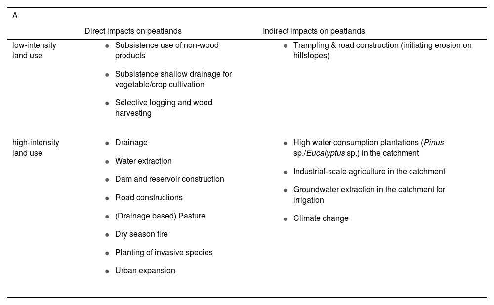
In peatlands, the main components vegetation, water and soil are strongly interrelated. If one of the components changes, the other two will be affected. Type and intensity of the impact will determine the level of change and subsequently degradation of the peatland components, and ultimately the possibility of recovery and restoration of the ecosystem (Joosten, 2021). In the following, we describe the various impacts of the different land uses on the Cerrado peatlands (Table 2).
Overview of land uses with impacts on peatlands and other wetlands (A) and types of degradation of the three peatlands components vegetation, soil and hydrology (B) in Cerrado stream valleys (Suppl. D).
| A | ||
|---|---|---|
| Direct impacts on peatlands | Indirect impacts on peatlands | |
| low-intensity land use |
|
|
| high-intensity land use |
|
|
| B | |||
|---|---|---|---|
| Vegetation | Soil | Hydrology | |
| Effects of degradation |
|
|
|
Especially the peat soil has a high fragility compared to mineral soils leading to strong changes in properties upon changes of environmental factors. When peatlands are drained and no longer water-saturated, the peat oxidizes, so that finer peat fragments are stacked more densely with less pore space. Soil compaction also occurs through direct physical impacts, like cattle trampling (Ramos et al., 2006; Nunes et al., 2022). Less pore-space means that water storage capacity decreases and water table fluctuations increase stimulating further decomposition. Peat is lost to the atmosphere mostly in the form of CO2 or washed out as waterborne carbon, resulting in subsidence of the soil surface. The surface drops towards the water table, resulting in less deep drainage. Land users react by deepening ditches again resulting in renewed losses and subsidence. This vicious circle of peatland drainage is seen everywhere around the globe (Joosten, 2021) and also in the Cerrado (Wantzen et al., 2012; Horák-Terra et al., 2022b; Santos et al., 2023).
When peat and organic soils fall dry, they become prone to fire. Peat soil fires cause the destruction of the soil structure, plant root systems and seed bank, which can cause a fast and complete shift away from the original wetland vegetation reducing cover and species diversity. Moreover, the peat becomes hydrophobic and does not retain and store water anymore, leading to a further drying of the peatland (Maillard et al., 2009; Turetsky et al., 2015). In regions of sandy soils and frequent fires in drying peatlands sand erosion from the upper surroundings of the wetlands leads to buried peat in the lower lying parts (Arenization) (Costa, 2021).
In drained or otherwise dry peatlands and wetlands in general, shrub encroachment by naturally less abundant species like Trembleya parviflora (D.Don) Cogn. or Baccharis sp., or the invasion by exotic species, e.g., Melinis minutiflora (P.Beauv.) or Pinus sp. have been shown to result in reduced species richness and diversity (e.g., Souza et al., 2022; Costa et al., 2023). More woody vegetation means higher evapotranspiration, exacerbating the water deficit in the wetland (Honda and Durigan, 2017).
The traditional land use of peatlands and other wetlands in the Cerrado includes selective and seasonal use of wetland-specific non-wood products, such as palm leaves, sweet juice or other parts of the M. flexuosa palms (Virapongse et al., 2017). Selective logging of the most valuable tree species and small-scale cultivation of crops, which is combined with shallow drainage represent more intensive uses (Table 2). However, due to the low intensity and the local and temporal limitation of these types of land use, negative long-term impacts seem limited, and natural regeneration is possible (Borges et al., 2023). Natural vegetation in peatlands and other wetlands is however changed through the higher intensity of cropping agriculture and through cattle grazing (Ramos et al., 2006; Santos et al., 2023).
The alteration of the basic hydrological conditions that are needed to maintain wetland systems causes their degradation and losses. Especially the hydro-geomorphological setting of the Cerrado peatlands makes them sensitive not only to direct anthropogenic interventions (Santos et al., 2022), but also to hydrological changes in their catchment (Woessner, 2023). Drainage canals and water extraction directly lower water tables in the peatlands. Roads or dams across the valleys cause downstream areas to dry and upstream areas to become wetter or even flooded (Wantzen et al., 2006; Araújo et al., 2023). High-intensity land use in the catchment can significantly reduce the groundwater supply to valley wetlands including peatlands causing their long-term drying (Vasconcelos, 2017; Honda and Durigan, 2017). In particular, groundwater recharge in the catchment is reduced through higher soil bulk density and lower hydraulic conductivity under croplands and pastures (Pereira et al., 2018) which reduce water infiltration into the soil by up to 90% compared with natural Cerrado vegetation (Hunke et al., 2015). Also, forest plantations with higher evapotranspiration rates than natural savanna vegetation reduce groundwater recharge increasing the water imbalance (Honda and Durigan, 2017; Ferraz et al., 2019). Finally, groundwater extraction for irrigation is actively lowering groundwater levels in the catchment (Vasconcelos, 2017; Rápalo et al., 2021). Road construction and deforestation in the direct surroundings of valleys often cause (gully) erosion, resulting in siltation of valley peatlands and other wetlands (Wantzen et al., 2012).
The current extent of suppression or deforestation of native vegetation, and the high rate of agricultural expansion in the Cerrado already significantly impact the water cycle (Rodrigues et al., 2022), posing a major threat to the region’s wetlands including peatlands. A wetland in northern Minas Gerais, for example, which is surrounded by cropland, has decreased by 25% in area (Brasil et al., 2021; Durigan et al., 2022). Urban expansion is another factor that adds to peatland and wetland degradation and loss (Araújo et al., 2023).
At present, the resilience of peatlands and other wetlands in the Cerrado is deteriorating under human pressure on the sites themselves as well as in their surroundings. Their current and projected loss shows a worrying trend in the face of a changing climate, which is anticipated to bring drier and hotter conditions to the region (Marengo et al., 2022).
Knowledge gaps and research needsPeatland distribution and extent in the Cerrado is yet underestimated. Very few soil carbon stock studies exist on wet grasslands, Veredas and riparian swamp forests although they form the most carbon-dense wetland vegetation types in the Cerrado due to the carbon stored below ground. In fact, systematic soil carbon assessments focussing on peatlands or other wetlands are lacking for the whole of Brazil. Studies on land use, land degradation and carbon stocks often group together wetland and dryland types of savanna and forest formations despite significant differences in their ecology and ecosystem functions. This likely led to an omission and, thus, underestimation in soil organic carbon stocks of peatlands and wetlands in general. There is a need for hydrological studies to quantify the role of stream valley wetlands, including peatlands, in the Cerrado water cycle.
The reasons why current knowledge on peatlands in the Cerrado is limited are manifold and include the following: (i) The concept of peatlands is not much applied to Cerrado wetlands, and a typology of peatlands is missing. It is seldomly recognized that wet grasslands, Veredas and riparian swamp forests can occur on and form peat. As a result, studies on these wetland types have mostly omitted the soil compartment as a relevant component of the ecosystem. (ii) The spatial variability and occurrence of peat in often small patches forming a mosaic with mineral soils, and the fact that Veredas and riparian forest cover both organic and hydromorphic mineral soils, makes the delimitation of peatlands difficult and their mapping challenging. (iii) Peats of less than 40 cm thickness are not classified as organic soils (e.g., Gleysols or Regosols) in the Brazilian soil classification system (Santos et al., 2018), and are thus omitted in soil maps. (iv) For a long time, research in Cerrado has targeted mainly dry forest ecosystems, leaving open ecosystems including most peatlands underrepresented (Durigan et al., 2022). (v) Significant knowledge acquired in the past, for example during PhD research, remains difficult to access. Relatively few studies have been published in peer-reviewed journals.
BOX C Legal and protection status of peatlands and wetlands in the Brazilian Cerrado
The Brazilian environmental legislation is considered ineffective and insufficient for wetland protection in general (Brasil et al. 2021; Durigan et al. 2022; Grasel et al. 2019; Rosolen et al. 2015). The wetlands definition in the federal Brazilian Native Vegetation Protection (LPVN) Law (12,651, May 2012) – the most important Brazilian nature conservation law – excludes e.g., areas of temporary or permanent water saturation, the latter encompassing peatlands (Chiminazzo et al. 2021; Grasel et al. 2019). In Veredas, only a 50 meter strip at the margins of the permanently wet part is protected, but not the permanently wet part itself, although state laws or interpretation of the LPVN in federal states may allow the protection of the permanently wet parts (Durigan et al. 2022). Neither peatlands, peat soils nor organic soils are explicitly mentioned or protected by environmental law in Brazil.
Consequently, activities with negative impacts such as cattle grazing and extraction of water for domestic purposes remain allowed in various wetland types. Further problematic regulations concern for example the delimitation of permanent protection areas (PPAs), the restoration of PPAs, or the monitoring of the protection of small streams and Veredas (Durigan et al. 2022; Grasel et al. 2019).
Hence, the evident general need for a more effective and inclusive wetland protection aligned with the Ramsar Convention and including peatlands by the LPVN and through improved management requires a set of measures including clearer, consistent definitions of all wetland types. To identify a wetland area in the field a minimum water table at the end of the wet season is recommended (Durigan et al. 2022; Grasel et al. 2019; Rosolen et al. 2015). In the frame of improved wetland type definitions, we recommend including peatlands into the LPVN and state environmental laws as a distinct wetland type due to their outstanding role in carbon storage and for water regulation. Although existing peatland definitions include organic soils with organic carbon contents higher 12–18% (Box A), from a climate perspective peaty soils with an OC between 8 and 18% should be protected equally since GHG emissions upon degradation can be as high as from peat soils (Barthelmes et al. 2015).
The catchments are hydrologically essential for the water supply to Cerrado wetland complexes, in which peatlands are embedded. In order to adequately protect wetlands by ensuring sufficient groundwater recharge in their catchments environmental legislation should reflected that hydrological dependency, e.g., through a landscape-based approach, and ideally regulate land-use in the catchment (Durigan et al. 2022).
A scientific definition and typologies of peatlands in Brazil and a better inclusion into wetland typologies would improve their recognition and visibility. A peatland definition should include two criteria: (1) a minimum thickness of the peat surface layer and (2) minimum organic carbon content. Key research should focus on the ecology of peatlands including patterns of vegetation composition, soil properties and hydrology and their (hydrological) embedding in the surrounding landscape. Their role for carbon storage and water regulation needs special attention. Mapping and monitoring of peatlands and other wetlands especially regarding their threats and degradation, should be a priority to enable adequate protection and management.
The urgency for action is underscored by the current high rates of deforestation and land degradation in the Cerrado (Alencar et al., 2020) and their negative impacts on the water cycle (Rodrigues et al., 2022), suggesting ongoing and unreported degradation and loss of peatlands and other wetlands (Nunes et al., 2022; Durigan et al., 2022; Santos et al., 2023). Despite clear evidence of these losses, Brazil has yet to report on carbon emissions from land use on organic soils (Brazil, 2020) and more research is needed particularly in terms of greenhouse gas emissions from (degrading) peatlands. Finally, Cerrado-specific knowledge of and capacities for peatland and wetland restoration need to be developed. An efficient protection and restoration can only be achieved by a better respective environmental legislation and its consequent enforcing (Rosolen et al., 2015; Grasel et al., 2019; Durigan et al., 2022) (Box C).
ConclusionsWe hope that this first overview of the Cerrado peatlands may serve as a catalyst for further research, given the urgent need for a deeper understanding of these critical wetlands. We highlight that the Cerrado vegetation formations of wet grasslands, Veredas and riparian swamp forests often occur on peat. The peatlands are part of wetland complexes in stream valleys and are fed by nutrient-poor groundwater. Together, they constitute a network that spans the entire region, playing a vital role in carbon storage and in supplying water to some of Brazil's major rivers and other biomes, as well as to the people who rely on the water. Despite the limited data on peatlands, we showed that they are the carbon-densest part in the Cerrado, by storing up to nine times more carbon per hectare than dryland ecosystems and about 13.3% of the total Cerrado soil carbon on only 0.7% of its area. This review indicates that the occurrence and importance of peatlands in Cerrado stream valleys is severely underestimated. In particular, carbon stocks and greenhouse gas emissions from peatland and wetland degradation have thus far received too little attention. These knowledge gaps need to be closed quickly by engaging in intensified research to inform management and protection policies, to sustain peatlands and all wetlands in the Cerrado.
FundingThis work was supported by the Heinrich Böll foundation, DE (grant number P147804), the Brazilian National Council for Scientific and Technological Development (CNPq)(grant number Universal 28/2018-408393/2018-1) and the Research Support Foundation of the state of Minas Gerais (FAPEMIG), Brazil(grant number Universal 001/2022-APQ-00458-22).
Conflict of interestThe authors declare no conflict of interest.
This paper has been written under the auspices of the UNESCO Chair “River Culture” and the EUCOR Excellence Chair “Water and Sustainability” granted to KMW. We thank J. Hartleib and B. Bobertz for valuable comments on data and visualization. We thank two anonymous reviewers for their constructive and very helpful comments.
The following are Supplementary data to this article:

